Showing posts with label okiwi bay. Show all posts

Monday, October 6

Wild Ride - Elaine Bay

We survived a wild ride last night, a ride that felt like an eight hour earthquake as the van rocked and bucked underneath us. It was our wildest night ever on the road. We’d arrived at the DOC camp at Elaine Bay yesterday afternoon. Elaine Bay is 17kms further on from Okiwi Bay on the otherside of the Sounds ‘arm’ that we are exploring. This side should have been more sheltered than the west side but now I’m not so sure.

The severe gale force winds that were forecast around the country started battering us early in the evening and by midnight were thundering over and under ‘Out There’, banging, crashing and rattling us from all directions while we hunkered down in bed waiting for the next big thump. Today we are shattered, I think we had about 3 hours sleep all night. Poor David must have made about a dozen forays out into the weather to check on things, shift the ute, tie down the boat and tie down the van! Thankfully it wasn’t cold and the rain only came for a brief time just before dawn which was also when the sky lit up with lightening!


We pulled the slide out in just after dinner when the wind started picking up, the awning that unwinds and protects the top is sprung-loaded & acts like a sail when the wind gets under it and we didn’t want to have that rip on us or pull out. We have quite often pulled the slide out in, that’s nothing new, it just depends on the direction of the wind.


But last night the wind just kept on intensifying and it swung wildly around us rattling the awnings on both sides so David threw a couple of ropes over the top and tied them off to the suspension. The boat was tied to legs of the van and he shifted the ute around to the front to try and break some of the force. That was good for an hour or so but then the wind changed and came roaring at us from the sea, blasting us with sea spray which has coated the van from head to toe in salt, and threatening to blow us over. I had visions of us climbing out through the escape hatch and a flattened ute. I kept recalling mentions of ‘willywhirls’ in the Sounds, great funnels of wind ripping down the steep sides of the hills and capsizing boats. Well never mind boats, I’m sure it was going to tip us over too.


Inside the van the noise was at times deafening, you could hear a gust winding up, roaring down the slopes around us as it whipped through the trees and then whacking us full force. I thought the roof hatches were going to blow out at every blast, I kept leaping out of bed to re-tighten them frightened the wind would get underneath and rip them off. In the end David tied them down with electrical ties. Finally around 6am the wind settled a little and we were able to grab another couple of hours sleep before it picked up again and has been battering us off and on all day.

David spoke to a couple who came down to check on us this morning, they had been worried as there has been a motorhome blown over here in the past. We couldn’t have shifted last night even if we wanted to as the wind was just too strong, along with the fact that there was nowhere to go close by, we’re on a small reserve tucked into the end of a bay with a steep narrow road up onto an exposed ridge. If this wind keeps up (and it looks like it might) we’ll hitch up the ute to add some stability to the nose of the van. David already has the ropes in place ready to tie down and the hatches have had the ties replaced and are ready and waiting. Wish us luck!


Of course, this blog post now hasn’t quite followed the sequence of events as they happened so I’ll step back 24 hours and post some of the photos from the trip over to Elaine Bay.

This is climbing out of Okiwi Bay on the other side of the harbour; Okiwi settlement is on the far left, Goat Hill (where I walked the track) is across the water, centre right. In the water just below you can see the remnants of an old mussel farm. The road up this side is steep and very winding, David had the ute in low-range 4WD and it handled the work load really well.


Once up the top, the road is an easy run along the ridge for the next 10kms or so before dropping down into Elaine Bay on the opposite side to this cove, which I see is aptly called Squally Cove. I bet the westerly wind whipped down this narrow bay last night.


Squally Cove is also part of Croisilles Harbour where Okiwi Bay is located. If you look closely you’ll see hundreds of rows of mussel floats lining the shore all the way around the bay. Here’s a zoomed in shot.


And the only reason we have such a magnificent view is because the pine forest below us has been felled, the slopes are now covered with pine seedlings and a mass of bright yellow- gorse bushes in flower. The air is saturated with a sweet perfume, I didn’t know that gorse could smell so lovely. I assume that this is where the logging trucks we were warned about, were coming from. They’ve long finished their job.


At the end of the tarseal the Elaine Bay road drops off to the right, a gravel road continues on towards French Pass.


Elaine Bay is a quiet little bay (well it was) with just a few holiday homes, a handful of permanent residences, a jetty, a wharf and a tiny marina. It is here that the mussel barges come to off load their sacks of harvested mussels. Mussels from the hundreds of mussel farms located around this part of the Marlborough Sounds. This does not include the farms in the photo above; they’re harvested from the other side directly to Nelson. The mussels that land here are loaded daily onto truck & trailer units that make the journey to Nelson twice a day. It’s these trucks that rumbled passed us while we were parked at Okiwi Bay and the ones we timed our run to miss when we came over the hills to Elaine Bay.


Looking back from the end of the jetty, you can see us parked to the left behind the bush. The yellow house (a holiday home) looks totally out of place in this environment, not only the colour but the size. The people that came to check on us this morning said that the glass panels around the deck were shattered on this house the same time as the motorhome was toppled over.


And with the wind still blowing a gale, this loaded mussel barge came down to the wharf this afternoon but didn’t off load it’s cargo. It pulled in for a minute and then backed out and headed off. We’re not sure if it was dropping someone off or it was too windy to offload.


OK - Okiwi

Okiwi Bay is a small sleepy settlement with 80 full time residents but where the population swells to over 1600 during the summer holidays. There’s definitely a good keen sense of community pride in the bay; little touches & signs that make a stay all that much better; from the slatted seats nailed to the tops of the rail and bollards that run the length of the beach to the rubbish collection depot where during a one hour window, two days a week you can dispose of your supermarket bag full of rubbish for $1 a bag- it doesn't matter that on the first day we went the guy forgot to arrive & the next time he'd gone on holiday & forgot to leave a key for his daughter to open the shed- she was throwing the bags through a hole in the netting up high! When ours went through I was waiting for the smash- as it hit the concrete on the other side, thankfully nothing smashed, it must have been a dry few nights! ;)

Then there’s the children’s playground and the reserve toilets which are regularly cleaned and where there is a donation box located outside. The Okiwi Bay Ratepayers Association, like all small communities, are keen to generate funds; the boat ramp also has a collection box, fees are $5 a boat and going by the number of boats that use it daily I assume they are collecting a good sum.

The first couple of days were warm and calm, this is the view from our dining table looking down the harbour.


Out our side window and across the front garden of the bach next door are the coffee cart and icecream kiosk; the coffee cart opening on the weekend only at the moment, providing coffee & a place to have a catch-up session for a steady stream of locals and boaties arriving back at the ramp.


Along the waterfront are the usual array of aged & well worn 1950-60s baches but up above the road and back into the valley are quite a number of larger and flasher holiday homes with great views out across the bay.


With a steady stream of boats coming and going there’s often a line up of boats waiting to be pulled out of the water. Unfortunately for them, the guys below timed their arrival to coincide with a visit from the fisheries officer who then spent the next 45 minutes checking, measuring & I assume arguing with the occupants. The officer was observed writing a ticket. There are scallop beds nearby and also a three fish limit for Blue Cod which is more than can be caught on the other side of this arm of the Sounds. The whole interior of the Marlborough Sounds is out of bounds for all Blue Cod at the moment.


Everyday there are a trickle of regulars passing by our van, either out on their daily walk or riding down to the camp shop located at the campground around the corner. Including this quad bike and farm dog. Numerous times a day I’ll catch a flash of black as the dog flies past at a phenomenal speed ahead of the bike which comes roaring around the corner a good hundred or so metres behind. The dog is so fast, he’s gone in less than a split second and on the way down to the shop he knows to take the back road which loops round and comes back onto the waterfront further down, he’s around the corner by the coffee cart before the bike has passed us out front, the bike continues on straight ahead meeting up with the dog (who is still going hell for leather) further along. On the way back he flashes past along the waterfront.

Yesterday I thought I’m going to capture him on the way back but I think the bike rider (who is usually going for it too) must have seen me as he called the dog onto the back and cruised on past us at a crawl. I could see the dog was thinking “hey, what happened? I want to run!”. Today the dog was on the back of the bike until they got to the coffee corner then he did a flying leap and he was off around the back. I think I spooked his master.


Everyday we have a visitor to the site, this beautiful male Paradise Shelduck, he comes to fill in his day as he waits for his partner to hatch their clutch of eggs. They have a nest down the other end of the beach near the stream that enters the harbour. After arriving early in the morning he brings her back to feed in the afternoon then escorts her home and returns once again in the early evening. The lady that owns the section has been encouraging them by feeding them but they’ve also taken to sitting on the road which isn’t such a good idea. I haven’t seen either of them today so I’m wondering if the ducklings have hatched and he’s been called to duty.


David has been out fishing a few times while we've been here, catching a few kawhai but no blue cod yet. The first time I went with him but it was too lumpy around the point and I was feeling queasy within minutes; there’s certainly a big difference between riding a a 10 foot dinghy and a forty foot catamaran. I think I’ll stick to exploring on calm days.


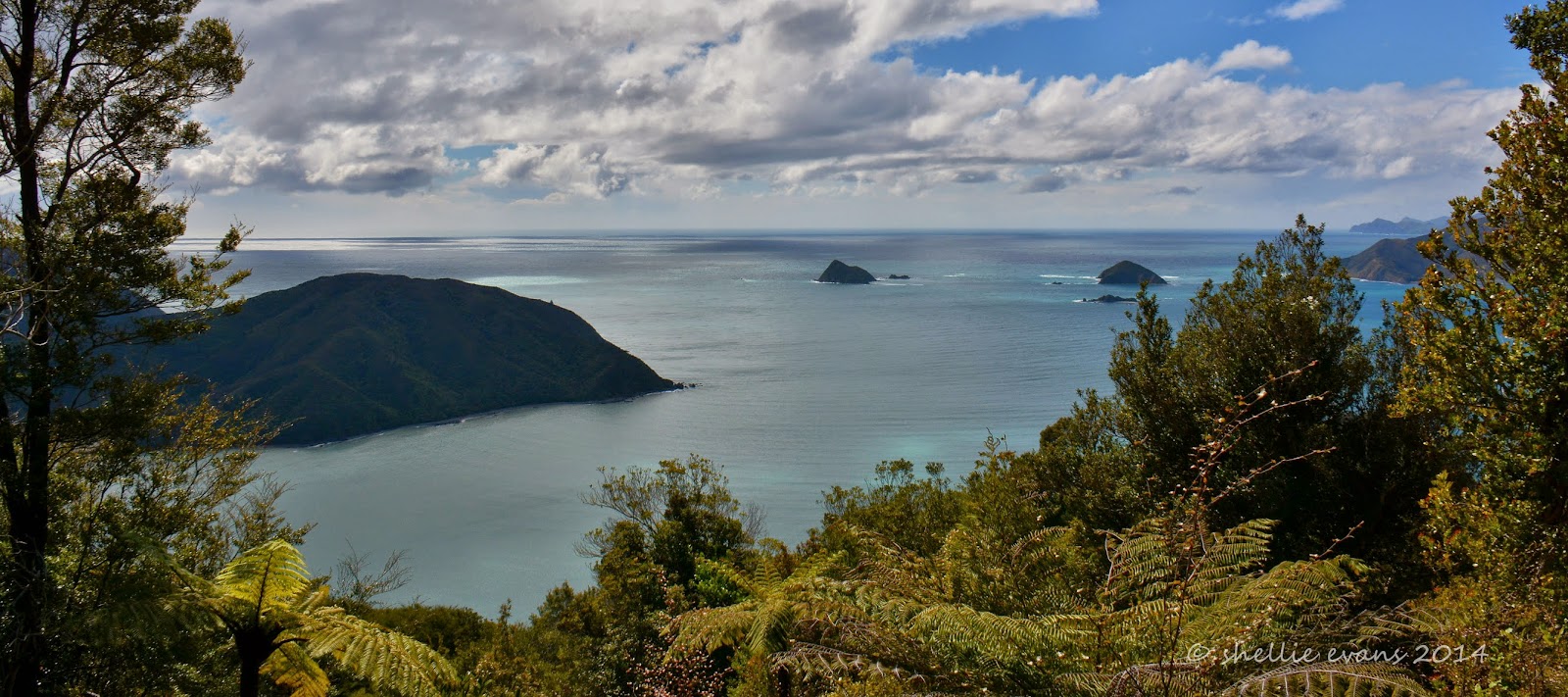
Before David went fishing yesterday I got him to drop me at the top of the hill back at the entrance to the bay so I could walk the Goat Hill Track which ran along the ridge and then dropped steeply down to the waterfront. The lookout was out over Whangarae Bay, the same bay that we saw for the first time when we arrived. The tiny islands are what we can see from our van at the end of the harbour.


Once I’ve passed the lookout, the track deteriorates quite significantly. There must be a lot of wild pigs in the area as most of the track along the top has been rooted up. And once passed the fresh diggings I can see that there’s also been a mighty storm up here on the ridgeline. There is windfall everywhere, giant trees toppled over with huge root balls retched out of the ground, other trees have been ripped apart with split trunks and many branches and smaller trunks blocking the route. Thankfully a chainsaw gang has been through cutting up the bigger trunks. I have a little trouble at first locating the direction of the track and then have to climb under, over and through the fallen trees every 10 metres or so. Such is the incredible power of nature.


I assume when I see, rather belatedly, the second lot of pink spray paint on the ground, that it must say something like ‘No access, route blocked’. Oh well I got through in the end. For the people that look after the track it would have been a shock & quite heart breaking seeing the damage for the first time and seeing how many mature trees had been toppled.


There was more windfall at regular intervals further down the track which gave me ‘peeks’ of Okiwi Bay. It may look close but it’s actually quite a distance to the bottom of the valley, after adding all the twists and turns, both the drive to the top and the track back down, were each about 4kms long. The peaks surrounding the bay are all around 1000 metres tall although Goat Hill (where the track was) is only about two thirds of that.


I zoomed in on ‘Out There’ parked on the site and what do you know? There was David in conversation again, this time with a passing local!


About half way down the sun disappeared and the rain started. I didn’t have my jacket with me so I tried walking faster, but as carefully as possible, between the overhead shelter of trees. The track was steep and mostly clay with a deep water drain (or mountain bike rut) down the middle which I had to try & keep in the centre so I didn’t slip down the sides of it. But…

Steep + Clay + Rain = Below. Twice! With a save on the third slip. Time to slow right down otherwise I’d have had to have been carted out of there on a stretcher. I also should have had my tramping boots on but you know how it is, it was just going to be a short stroll down the hill. It was lucky I had decided to take my small backpack with me just before we left, at least I had a snack (chocolate bar to sooth hurt pride) and water on board. Oh and my wet bag for my camera but no jacket for me.


I stopped at the last view point just a short distance from the bottom of the track and waited there for the rain to ease a little. I called David on the walkie-talkie to let him know I was nearly to the bottom and all was OK. It was a surprise to find that we had clear reception as they don’t usually work around bush.

Of course from then on the track was bone dry and totally covered by overhead trees. At the bottom of the track, it was a short walk home along the road for a bit, down to the beach and around the point before crossing the stream (shoes already wet & dirty) and along the waterfront to the van. David had managed to walk the dinghy down to the boat ramp by himself and had gone fishing.


Neither of us had a very fruitful afternoon.


Saturday, October 4

Two Cables –Two Bays

Yay! We have internet access for a few days, here's the first of the Marlborough Sounds blogs.


On our way to Okiwi Bay we took a side road just out of Nelson at Hira, initially so I could check out the “Skywire” an impressive looking flying-fox capable of carrying 4 people at a time flying high up through a valley on a 3.5km return journey reaching speeds of 100kph. I fancied having a go although the mention of a backward fall at high speeds had me reconsidering for a time and as it turned out when we arrived at the place there was no sign of the highwire and nobody about, just quad bikes, paintball, horses and other farming paraphernalia.

We didn’t stop but from what I saw I think you must be transported across the farm to the site of the flying-fox. The road was narrow and with no place to easily turn around we decided to carry on to Cable Bay and have lunch before returning.

Towards the end of the road the view opened up over a large estuary with an low lying isthmus (Maori Pa Beach) in the distance, there must be a break in the sandbar that lets in the water. The road winds it’s way around the sea cliffs with numerous holiday homes built into the slope. It also looks like a serious storm has damaged the road as there are many washouts along the way. Road cones galore line the edge & wire cages full of rocks, looking like a giant’s staircase, step down the hillside to the water far below.


It’s not long before we reach the workmen, diggers & trucks and an area where the road is seriously narrow. I may have to get out and shift a few cones but the guys spot us and are very helpful if a little incredulous when they see what we have on the back. The digger moves into a drive and the trucks are far enough to the edge that we’ll be able to squeeze past. We thank them and let them know that we’ll be back past in an hour or so. “No worries, mate!” Even if we feel like we’ve inconvenienced them, they are quite happy. All part of the job.


At the end of the road there’s another isthmus, with the estuary on one side and the ocean on the other and a tiny beautiful turquoise coloured bay. The road crosses the bar but finishes at the base of Stuart Hill, an “island” which it actually isn’t as it’s tethered to the mainland by the gravel bank. Which is what I think DOC are referring to as the “nationally significant natural feature”.


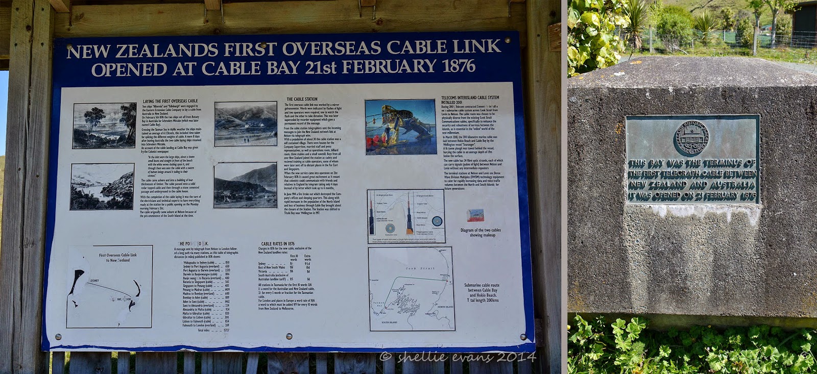
The Cable Bay Walkway, an 8km walk along the coast & over private farmland, leaves from Glenduan (just north of Nelson’s Boulder Bank) & finishes here in the bay. Unfortunately (or fortunately as the case may be) the walk is closed for lambing at the moment. But I climb over the locked gate so I can walk up to the shelter and information board that is located higher up the hill.


It’s here in Cable Bay that the first cable that linked Australia to New Zealand opened in 1876. Two ships set off from Botany Bay in Australia laying a cable across the Tasman Sea, averaging 6.5 knots the ships arrived in Schroders Mistake (renamed Cable Bay) just 11 days later. When the new cable system came into operation it meant that people could communicate with the friends & relatives in the “Motherland” (UK) by telegram taking 4 days instead of the usual 6 months it took by letter.


The view is spectacular- you’ll see that the top two photos form the bay. It was a surprise to see a small duck weed covered pond located just a little higher then the shoreline. It was lovely and sunny sitting outside having our lunch overlooking the bay. A few families were also about enjoying the sunshine.


Looking back down to the vehicles I see that David is engrossed in conversation and it isn’t a surprise to find him still talking when I get back down to the van. I think he should write a book on the interesting characters he meets on our travels, you wouldn't believe the stories he could tell.


It was soon time to hit the road again, we still had 60kms of winding road to travel before reaching our destination. We smiled and waved as we edged our way back past the road works and looked in again on the flying-fox operation but with no one in sight and the place deserted we decided to give that a miss for now. We wind our way up and over the Rai Saddle and down into the Rai Valley where we turn left heading for Okiwi Bay.

Just after turning we’re confronted with a plethora of signs with distances and some information on each area. This ‘arm’ of the Marlborough Sounds reaches up to French Pass with D’Urville Island across the Pass, a finger towards the end reaches into the Sounds proper and it’s where Bulwer is located 80kms away.

I’ve never heard of Bulwer before so I’m looking forward to taking a trip out that far to check it out. Our first stop will be at Okiwi Bay, we’ll then move onto Elanie Bay and maybe make it as far as French Pass with ‘Out There’ on the back.


The yellow AA signs on the right point down another road just past the main information board, down to Duncan Bay & Tennyson Inlet deep inside the Sounds.

The first section of the road down the valley is fine, just another country road with dairy farms along both sides. Then we start to wind our way up and through native bush, the road narrow but not too bad, just enough to keep us on the alert and attempting to look ahead around corners. We’ve heard that you can meet logging trucks but we’re lucky we only see a couple of cars. There’s also the mussel trucks, but we’re yet to know about those.

We catch glimpses of beautiful turquoise blue water through the trees as we get closer to the coast but for most of the time the bush is too high to get a clear view until finally a clearing gives us a wonderful view out over a bay below. This is Whangarae Bay, part of the larger Croisilles Harbour which Okiwi Bay is part of too.


Not too much further on we pass over the top of the ridge and start to wind our way down into Okiwi Bay, our base for the next few days. Okiwi Bay is a small bay tucked into the back of Croisilles Harbour with a narrow entrance which gives the impression it will be quite sheltered. Famous last words. While it hasn’t been too bad, the surrounding peaks are all over a thousand meters tall and act like a funnel with the wind either roaring down and across the harbour or up the harbour and over the top.


Down at sea level we head along the waterfront looking for the NZMCA CAP site (costs apply parking- $7 per van(2pp) per night), finding it about halfway along across from the water and just 50 meters from the boat ramp. What a perfect spot!


There’s a house truck already on site; a family of five with their dog, car & boat. They’ve not long rented out their house and are now also living full time on the road and loving the lifestyle. I can’t help but think what a handful- & how stressful it might be- they have 3 children including 22 month old twin boys who were on the go from dawn to dusk and beyond.


We set up camp on the front edge of the site and marvel at such a great spot to have a camp. And even though it’s the school holidays there’s hardly a soul about (if we look north; out the back, it’s a different story!)