Showing posts with label turkey. Show all posts

Saturday, October 1

Beach Hop South- Blackhead Beach & Turkeys

Real-Time

While staying at Porangahau Beach we did a short tiki-tour north to visit Blackhead Beach and then looped around one of the back roads home again. 

Here's a first for the blog- it's not everyday the lead in photo is of a killing-shed (I think I can safely say it'll be the last time too). This is Porangahau Station's historic killing shed which would have been used to slaughter sheep and cattle for the station's families and as dog tucker. It even has it's own sign pointing across the paddock to it's location. 


I didn't know I had an audience watching my every moo-ve as I took photos of the shed until I turned around. I don't think they see too many people walking up their road with a camera; David had driven off to turn around leaving me to talk to these guys for a minute or two. 


This is the former Porangahau Station homestead which is now called Chapelwick and is a luxury bed & breakfast. 


Set on 18 acres, the estate has beautiful gardens and lawns, mature trees and an orchard, a swimming pool and tennis court along with the historic Station chapel where many weddings are held. And for any NZMCA members reading, Chapelwick is also a CAP (costs apply parking), although it is rather expensive at $20 per night. There I go, it's not THAT expensive but in the scheme of things when you're paying $5 or it's free elsewhere, it seems expensive. On the plus side, you can play tennis, swim in the pool, and walk around the beautiful gardens like you own the place! 


Chapelwick also holds regular events in it's grounds over summer; old English garden parties, garden fetes and craft stalls. 


With not much more to see other than farm stations and woolsheds along the road to Blackhead Beach I managed to convince David to stop for a couple of woolshed shots.


Blackhead Beach has a small settlement of baches and holiday houses at the south end of the beach.


They are reached by crossing a small bridge which I'm sure gives the owners a sense of security. It's like entering a 'gated' community, there;s sure to be a few pairs of eyes watching anyone crossing the bridge- a bit like Billy Goat Gruff- 'who's that tripping on my bridge?'


Blackhead Station woolshed takes pride of place in the middle of the bay...


...and along with a few more houses, the Blackhead Campground and reserve is at the north end where there's also public loos and picnic tables. There is quite a deep ford and a sharp turn into the camp which would mean camping here is out for us, we wouldn't be able to get the 5th-wheeler through the ford.


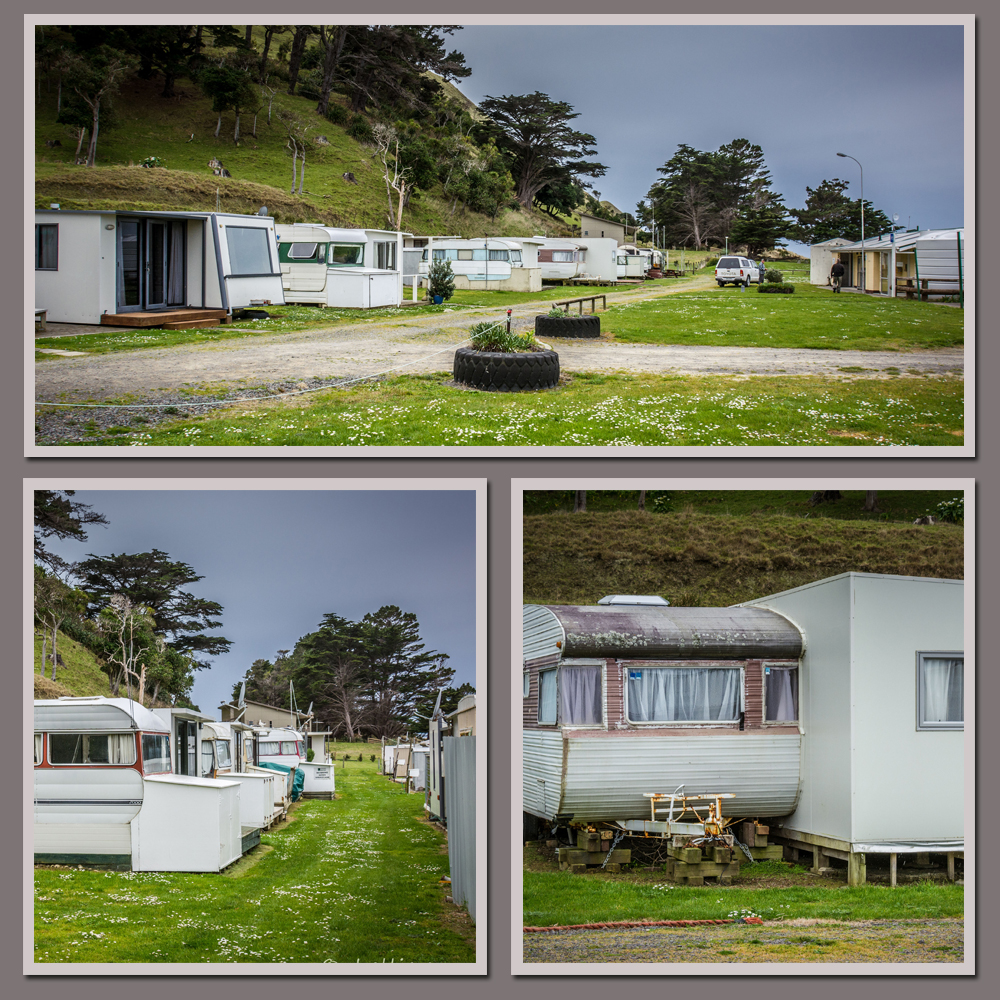
It's a small campground with a number of permanent caravans on site but with plenty of green space at the rear to park motorhomes and mobile caravans. The weather deteriorated just after we arrived and the rain started just as I laid lunch out on one of the picnic tables. We quickly gathered it together and drove to the top of the reserve and backed in underneath one of the large macrocarpa trees and had lunch sitting on the tailgate. We finished just as the first few big fat drops of rain found their way through the branches.


Blackhead Beach is at the southern end of the Te Angiangi Marine Reserve, and Aramoana is at the northern end of the reserve. You'll remember we missed getting to Aramoana because of the muck-up with Pourerere. There's just 2-3 kms of coastline between the two beaches, and yet by road it's about 40kms (on a rough gravel road) or about 80kms if you go via Waipukurau.


The reserve includes a large area of inter-tidal platforms- perfect for exploring at low tide, a boulder bank and a very sheltered bay ideal to people to learn to snorkel. We were going to walk up to Aramoana, well in fact we were going to drive the beach up to Aramoana but David decided that salt laden wet sand and a clean ute weren't going to work. And by the time we arrived the tide was on it's way back in, and it had started to rain. So we gave it a miss and put it on the 'low priority, must do sometime list' 


And if we do make it back, I've decided I want to check the reserve out in comfort & style. David can hook this up to the ute and I can invite a few others along for the ride!


After lunch we made our way back up Blackhead Road and rejoined the loop. I'd seen this woolshed on the way in when I made a mental note to stop and take its photo on the way out.


It was an added bonus to come around the corner and find a flock of turkeys (aka as a rafter or gang) wandering down the middle of the road in front of the shed. Of course when they saw us they took off, running down the fenceline while the dominant male (known as a Tom or a Gobbler) flew off into the middle of the paddock and set about remonstrating with them for not following suit. Some protector he turned out to be.


You wouldn't believe how many turkeys we've seen as we've made our way south along the coast through the lowland farms and stations. Dozens of flocks both large and small, although most seem to have around 10-12 birds. Many were feeding on the roadside and took off as soon as we approached. Others were hanging out around the yards and woolsheds like this group.


Once back on the Porangahau Road we took a short detour to Wallingford Station (Wallingford Homestead is another POP(park over property) where NZMCA members can park for free as long as they purchase a 2 course dinner and a tour around the historic homestead and gardens! Surely that's a CAP(costs apply parking) and an expensive one at that....there I go again!) Anyway, we pulled into Wallingford's woolshed drive but the shed was hidden. Then a movement in the trees caught my eye and...


...there in the trees on both sides of a fence were about three dozen turkeys- strutting, flapping, eating and gobbling! 


I have never looked at turkeys in great detail, they have always been a strange looking bird but, really, these guys take the cake. 


They- well, the males anyway- are the most peculiar looking bird I think I've ever seen. It would seem that there is more than one dominant male in this group. Either that or there's a power struggle going on.


There were a number of  younger males, known as Jakes, in the group and they seem to keeping close to the hens, not challenging the older males but keeping in sweet with them and keeping an eye on the harem. Just close enough to dive in when the Toms were otherwise occupied, I'm thinking. 


Most of the males were strutting their stuff- gobbling calls bouncing off the trees, bright red or pasty pink wattles wobbling on their throats, tails fanned, wings fluffed and down- challenging each other to a dance off- a type of synchronized waltz, they strutted forward and back, up and down, turning and pirouetting around each other. 


I can now see why Native American Indians had turkey feather headgear; they had a ready made fan.


Nature sure is a wonderful thing, but sometimes you've got to wonder if it got things a little wrong- I'm sure his mother loved him.


This very large swamp was right next door to the turkeys- you can now see the Wallingford Woolshed at the back on the right. A huge waterway teeming with birdlife and frogs! I opened the door and the sound of a thousand frogs filled the air. I gave a shout and it went deadly quiet. But not for long. I'm glad we're not parked beside this lot.


At regular intervals throughout the pond were a dozen or so large mounds of reeds and grasses and on top of each of them sat a black swan, incubating her eggs and patiently awaiting the arrival of her fluffy little bundles. We spend 10 minutes or so scanning the pond to see if there might be something unusual out there, but no it was just the usual suspects.


And just across the Porangahau River, not far from home I finished our day with a shot of this 'rustic' woolshed that is on it's last legs.


Monday, September 21

Maniototo- Out in the Styx; Part 2

Carrying on from Part 1

After driving through Patearoa, we continued on up the Maniototo valley passing along the way, quite a number of new dairy conversions and some still under construction. It was a surprise to see dairy farms all the way out here, I wondered where the closest dairy factory was, we haven’t seen any tankers on the road while we’ve been in the area. We slowed to let the tail-enders of a large herd cross the road, followed by a couple of quad bikes with farm workers on board. Most of the farm labour we’ve seen around the dairy farms here and further south have been Filipinos. I bet the Maniototo would have been a major culture shock for them, especially the isolation and the bitter cold.


We leave the dairy farms behind and move into sheep country, large station homesteads appear here and there and near the entrance of one, we stop to take a photo of this old salvaged & restored gold dredge.


Further on we pass Patearoa Station’s beautiful stone woolshed….


…which is across the road from this long abandoned homestead. The 5000ha Patearoa Station was purchased by the Hore family a few years ago and added to their own large station next door.


The 8000-odd hectare Stonehenge Station is home to the Hore family, this is the family farm of past All Black Andrew Hore whose great-grandfather came to the Maniototo in 1910.

Stonehenge Station cottage and farm shed.


We pass over the Tairei River once again, it’s getting narrower so we must be nearing it’s source. There’s also a couple of small power stations on the banks of the river. We start to climb again and we’re looking for a sheltered place to stop for a late lunch.


Towards the top of the rise we pass over a large pipe that is channeling water down to the power stations below. The view out over the vast Maniototo Valley is stunning, small irrigation ponds and dams are glistening in the sunshine, and across the valley is the snow capped North Rough Ridge.


At the top I spot an NZ Fish & Game angling sign beside a closed gate. There must be a lake or dam nearby so we decide to check it out and maybe find that place to have some lunch. We follow a steep track up the side of a bank and find ourselves on top of a dam wall and beside the intake to the pipe. This is the Paerau Irrigation & Power Scheme and a track follows the dam walls in both directions.


We head towards the far end of the dam and before we realise it, there’s a large mob of sheep advancing on us (coming round the mountain). They think we’re the farmer and have their feed with us.


They hesitate for a moment & we make a hasty retreat and finding no shelter beside the dam to have lunch, we park on the track between two huge rocky outcrops. It’s once again bitterly cold outside with a stiff wind blowing but at least the rock offers a little bit of shelter as I pour the soup standing between the open doors while David stays warm in the cab. The white on the rock beside his door are frozen icicles, water that has seeped out of the rocks has frozen on it’s way down the rock face.


We don’t hang about and nor have the sheep, they ambush us on the track over the intake. They must have taken a short cut because we didn’t see them pass us by.


We nudge our way through avoiding eye contact as they stretch their heads upwards looking expectantly for food. When we look back there’s still dozens coming over the rise. We can’t get out of there fast enough. What's with sheep and us, we seem to have spent much of our time in the Maniototo being harassed by hungry sheep.


We carry on down the road, we’re getting close to the end of the road. This is Paerau (meaning many ridges) and formerly known as Styx, as in ‘out in the styx’- and this really is out in the styx, the back of beyond, the wops, miles from nowhere. This road does end, but before it does, it crosses the famous Dunstan Trail, a trail used by miners on their way to and from the inland gold fields of Central Otago back in the late 1800s.

The Dunstan Trail is a Dry Weather Track (summer only), we drove part of it on our way to Poolburn Dam the other week and hopefully we’ll be back to drive it’s length next summer. There are other tracks that branch off from the Dunstan Trail, one heads to Lake Onslow- The Dismal Swamp, where we visited awhile back from the Roxburgh side of the range. Another track passes the most isolated church in New Zealand, the Serpentine, a rough stone ‘hut’ out in the middle of nowhere. Of course I’m hoping we’ll make it to there too.


We cross the Tairei again and as we head up the other side I spot some old buildings down the bank beside the river. These are what I’m looking for and one of the main reasons we’ve driven to the top of the valley.


At the top there’s a gate and a track leading down to the river. It’s private property with a sign on the gate.


This is where the old Styx jail, hotel and stables are located. This is also the junction with the Dunstan Trail and it’s where miners stopped for the night- there were originally two hotels, one on either side of the river so there were options if it was in flood. The Styx Jail was built in 1863, but rather than for prisoners, it was mostly used to secure gold during overnight coach stops.


I thought I had it sorted but the sign wasn’t to scale and didn’t quite make sense (to me anyway), we were parked at the sharp point on the sign, at the Dunstan Trail junction. Talk about being picky- the owners of the land around the jail must have had issues to be so pedantic. But it didn’t matter because when I got to the bottom of the track I found I couldn’t get to the jail anyway due to having to cross the river.


There was no way I was taking my socks & boots off and crossing through the ice cold water and it was actually about knee deep even though it doesn’t look it here. The stables were visible and another building which was possibly the old hotel but I couldn’t see the jail even through the bare trees. I was a bit disappointed not to actually see the jail but  that'll be another reason we’ll have to come back this way in the summer.


As I was getting back into the ute, we heard a whole lot of revving and laughter coming from the Dunstan Trail ahead of us, and high up on the range we spotted three 4WDs weaving their way down the trail. They disappeared into a gully for awhile; we could still hear the revving and yahoos, before they popped over the rise in front of us. They skidded and spun their way out onto the road and were gone, as fast as they appeared.


We turn around and followed their wheelie tracks back up the valley before we turn off and head across the head of the valley to the west side. We stop at another old stone woolshed, this one I think is on Linnburn Station.


A little further on we pass the another entrance to the Dunstan Trail, not too far over the range is the Poolburn Dam. The section of the trail between here and the Styx is the one we’ve just travelled and is the normal public road.


The sun comes out as we turn our nose towards home and head along the bottom of North Rough Ridge passing more sheep stations, deer farms and dairy herds along the way.


Ahead of us I spot a gang of turkeys near the roadside fence- I like gang myself, but rafter or flock, they all refer to a group of turkeys. We pull up so I can take a photo just as I spot another flock of sheep making a beeline across the paddock towards us. ‘Quick,’ I call to David ‘Let’s get out of here!’

Just around the next bend is another larger gang of turkeys spread out across the road. They dash for the fence and as we slow down peel off to the left, running fast along the fence line trying to find a break in it to escape.

I know what my family will be thinking reading this; did you lean out the window Shellie and go ‘gobble, gobble, gobble!?’ My mother did this when we were kids, whenever we’d pass turkeys while out driving around the countryside (in fact she’s been known to do it when we were adults too). I think (I bet) she got it from her father- if you get the call right, the turkeys will answer back. They didn't talk to me.


The long & undulating road home- it was a shame the cloud hung low over the snow covered mountains ahead of us otherwise this would have been a magic shot. All the same, and despite the weather and the chilling cold, we had a awesome day exploring the beautiful Maniototo Valley.


And that was us for the Maniototo too, we left Ranfurly a couple days later driving over the Pig Root (Kyeburn to Palmerston) and through to Kakanui, heading north to see our family again. We decided we'd do the last third of our Cheats Otago Rail Trail, from Kyeburn to Middlemarch, later in our travels.

We had an awesome time exploring this amazing part of the country and especially doing it during winter. I missed my hoar frost (much to the relief of the locals) but we had our fair share of snow, ice and beautiful winter sunshine along the way. Our 5th-wheeler did us proud, we were so toasty warm because it is so well insulated. We hardly needed our second diesel heater- we have two, one in the bedroom and one in the lounge. And as long as we layered up with clothing we managed very well outside in the sometimes extremely cold weather- one day we woke up to -12 degrees Celsius. An extra bonus was the lack of people, we could have been the only people on earth some days.

We'll definitely be back another day, another season.