Showing posts with label waimate. Show all posts

July 28, 2020

A Historic Tiki Tour of Waimate North

Catch-up; Northland Jan 2019 

While David recuperated from his bout of shingles I took myself off on several tiki-tours around Northland, the first one on a several squiggly loops to check out a number of churches and historic places in the wider Waimate North area. Northland has a multitude of small & historic churches and I was keen to add a few more to my church photo collection.


My first stop was on SH1 just south of Ohaeawai, at the historic Pakaraka Anglican Church of the Holy Trinity and probably one of the most visited & photographed churches in Northland due to it's location on the main highway. 


The church is Gothic Revival in style and the slim steeple is a replica of the original tower which blew down in a storm in 1946. The new steeple was erected in 2001, 55 years later. The Reverend Henry Williams, one of the first Anglican missionaries stationed in the Bay of Islands and later Archdeacon of Waimate, is buried in the cemetery.


The next church is located on a back street, not far along the road at Ohaeawai, which is a small settlement at the junction of SH1 & SH12. I believe this is an Anglican church but I could find no other reference to it and it's obviously taken a back seat to several other more historic & prominent churches in the area. Like many of the churches around New Zealand, this one is sadly heading to a state of disrepair...


...unlike the nearby Ohaeawai Hotel (locally know as The Crossroads) which looks to have recently had a fresh lick of paint. I bet this grand old lady could tell a few stories if only the walls could talk. 


My next stop is at Te Waimate Mission where the remains of a model English village, built by missionaries is located. The Mission House, built in 1832, is the only survivor of three mission houses built in 1830 on behalf of the Church Missionary Society by the Reverend Samuel Marsden (click photo to enlarge)


The Mission House is also New Zealand's second oldest building. I felt a bit mean about not going inside to check it out; I was in a bit of a hurry. And especially as I was the only visitor in the grounds and the volunteer guide came outside to greet me. I had to tell him I was on a mission (no pun intended!) 


Te Waimate was New Zealand's first farm and had a very famous visitor; scientist & evolutionist Charles Darwin stayed here for the Christmas of 1835.


Nearby and part of the mission station is St John the Baptist Church which was originally built in 1839 and then rebuilt in 1870 using materials from the first church. the new church was much smaller due to the drop in congregation numbers. 


Located between the Mission House & the church is the Sunday School building, built in 1880


Not far down the road, and part of the original mission settlement are the remains of Bedggood Cottage & the Blacksmiths Shop.


The Blacksmiths shop collapsed in 1979 and was reconstructed in 1986 using the original building's materials.


From the mission I next headed to the historic St Michael's Anglican Church at Ngawha.


St Michaels Church was built in 1871 and is located on the site of Pene Taui's Pa, which is where Te Ruki Kawiti successfully defended the Pa against British forces in what is known as the Battle of Ohaeawai. It was built by local Maori as a symbol of peace and a tribute to Pakeha who had died in the battle.
On 1 July, 1845, almost 600 troops and 300 warriors of Tāmati Wāka Nene besieged about 100 men at a pā at Ōhaeawai led by Lieutenant Colonel Despard. Te Ruki Kawiti held off the attack on the highly intricate and fortified pā of Ngāti Rangi chief Pene Taui. The fortifications were ground-breaking in every way, and became one of the prototypes for gunfighter warfare in later engagements. 
The pā had two palisades - including a strong inner fence made of puriri logs set almost two metres into the ground with five metres of log standing above ground. The solid palisades of the inner fence had withstood the artillery attack and remained intact, preventing the British from entering the pā. Meanwhile, the firing trenches proved devastatingly effective against the attackers. "Within seven minutes of the attack beginning, over 47 of the attackers lay dead with about 70 more injured. The attack was an unmitigated disaster."
By 8 July, the pā was found to have been abandoned and the defenders had disappeared into the night. Lieutenant Colonel Despard suffered a defeat. (extract from RNZ)

From St Michaels I headed down the highway towards Kaikohe, stopping to check out the Kaikohe Showgrounds & Equestrian Centre which is a NZMCA CAP (costs apply parking). It's where I thought we'd stop for our first night once David was ready to move and we'd left our friends in Kerikeri. It's a great site, well maintained and with lots of space. There's even a couple of  sites with power.


The Showgrounds are on the corner of the road that leads to Ngawha Hot Springs so I drove off to take a look; I do love it when I'm on my own and I can pick & choose what to visit & where to stop. Poor David does get dragged down a few too many roads, it's nice not to feel guilty about it today. 

Ngawha Pools- there are 16 of them- are fed by a natural geothermal spring and come in a range of temperatures including the 50 degree Bulldog pool which was closed (for obvious reasons!).
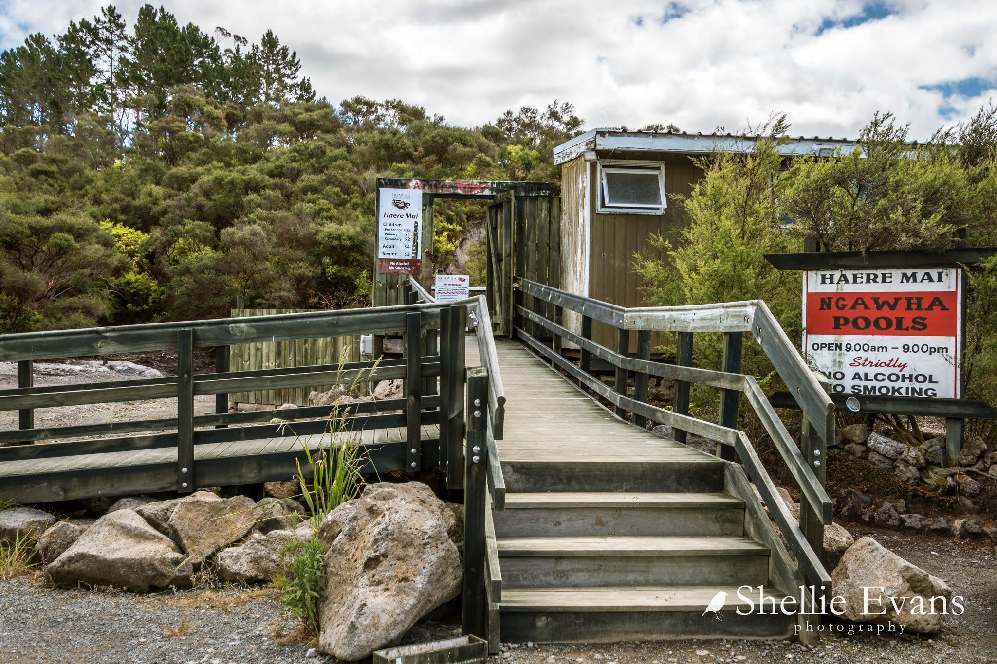

The Ngawha Pools will never look like this again, they are going through a major redevelopment and enhancement programme at the moment and have been closed from March 2020 until December 2020. Obviously the redevelopment was needed, the pools are very popular amongst both local & overseas tourists but it's a shame the unique character of the pools will be lost to flashy frontages and further health & safety features.


From Ngawha I drove into Kaikohe and up to the top of Monument Hill where there are great views out out over the surrounding farmland and from where I spotted the second to last church on my visit list today.


Monument Hill is named after the memorial that celebrates Hone Heke Ngapua who was the grandnephew of the war leader Hone Heke. Hone Heke(the warrior) retired & died in Kaikohe in 1850. 


Hone Heke Ngapua (grandnephew) was a member of parliament & active supporter of the Maori parliamentary movement known as Kotahitanga (click on the photo to read)


Hone Heke Ngapua Memorial

I drove down and along the highway to the Aperahama (Anglican) Church which was opened in 1885, the church I'd seen from Monument Hill. The church belongs to the Ngati Tautahi hapu (hapu= a division of a Maori tribe) & is essentially a Maori church although European families belonged to the congregation for many years. 


The church was restored & repainted in 1964 and is not only significant because of it's age but also because of its association with the development of the Maori Anglican faith.


The last stop for the day was at St Catherines Anglican Church near Okaihau.


Information panels across the road from the church tell about the first battle in 1845 of the Northern Wars and the memorial in the cemetery to the 12 fallen British soldiers. The Twin Coast Cycle Trail passes the church which is just as well as these information panels often provide a lot more information than what can be found on the 'net, especially history on the lesser known churches and historic places.


I know I missed a few other churches on my road trip, and in particular the Catholic church just up the road from this St Catherines. I had marked down as many as I could but it was quite hard locating them once I was on the road. Especially when much of the area was out of range to Mr Google when I went to check!  

I told myself that I had to leave some for our next visit to the north. From Okaihau, I took the most direct route back to Kerikeri. And didn't spare the horses, it had been a long day.


June 29, 2020

An Eventful Afternoon in Waimate

Catch-up (mid Nov 2019)- Gordon Bennett! Is it that long ago, just feels like yesterday. Here's the last blog from our stay at Glenavy before we headed up to Lake Benmore for Christmas & New Year.

I wanted to check out the murals on the sides of the Waimate Silos so I took myself on an afternoon tiki-tour. I thought I'd drive to Waimate 23kms away, then head up the Waitaki Valley, cross the river to Kurow and come back down the other side. 

The last time we stopped in the area was way back in 2013 on our very first trip to the South Island, we stayed at the recently opened Waimate NZMCA Park and explored some of the area, including driving nearby Meyers Pass where I was very excited to see for the first time, a few spindly lupins in flower & another first, a dead wallaby! 


The silos were a blank canvas back then, they have only recently been painted, in May 2018.


I stopped on the roadside on the way into Waimate to take some photos of a large wheat field. You can't see it in the photos but I love the rippling movement and the rustling of the wheat as the wind swishes the ripening stalks back & forth. I also spotted a flock of green finches having a feast in the middle of the field. They were very skittish, chattering as they tried to settle, then lifting off every few seconds as the wind spooked them. 


And then when I looked around I could see why, I thought I'd better get my skates on, a massive dirty great black cloud was settling right over Waimate township.


Although by the time I got to town the dark brooding cloud had moved over to the hills behind.


Great I thought, I had time to walk the silo loop, a pedestrian loop that circles the outside of Transport Waimate's business premises and where you can view the murals, read all about them and not get in the way of the comings and goings of the businesses' stock trucks and other vehicles. Although I had to wait it out several times to capture a clean shot with no vehicles in the view. 


The silo project was the idea of  Transport Waimate's boss who commissioned Waimate artist, Bill Scott, to paint a number of local heroes on the silos. Click on the photo to read the history behind the silos & the people depicted in the murals.


I had just set off along the back of the loop when that big black cloud came back and dumped a solid sheet of rain on the town. Luckily I managed to scramble back to the ute and get inside just before it bucketed down. 


I sat the rain out for 10 minutes or so and after it had passed returned to finish the pedestrian loop.


The next local hero was 'Big Norm', Norman Kirk, a former New Zealand Prime Minister (who is walking hand-in-hand with Moana Priest). 


I wonder how many of you can recall where you were when you heard that Norman Kirk had died? I can. For some reason it has stuck in my head for over 45 years.  I had just gained my drivers license and was allowed to take the family car, a Holden HQ stationwagon, from the farm down to our local shops to collect the Sunday paper (and Dad's Park Drive tobacco).  Splashed across the paper's front page was the news of  Norman Kirks sudden death. I remember being shocked and when I got home, running up the path and calling the news out to the others before I'd even got into the house. 


And the last two figures are a tribute to two well respected local men that led by example; Michael Studholme & Chief Te Huruhuru.


There is another mural on the back wall of the silo buildings, one of another Waimate hero (heroine), Stella Chamberlain (a stellar lady?).  


This was one incredible lady, click on the photo to read her story. Stella certainly deserves a medal not only for her 35 year dedication to the Waimate Rugby Club but for having 13 children of her own to look after too!   


There are several more murals on the walls around town and I stopped to look at a few of them on my way to the next photo subject.


I couldn't believe my eyes when I pulled out back onto the main street, that big black cloud was heading our way again.


I'd taken photos of some of Waimate's historic buildings on my last visit but there was one I had overlooked, Quinns Arcade. I shot around the back of town and stopped to shoot the arcade as the cloud rumbled closer.

Quinns Arcade was built in 1906 from Makikihi bricks that were fired at William Quinn's brickworks, north of Waimate. The Arcadia included two dozen shops, twelve each side of a wide passage that led through to High Street. In 1920 Quinns Arcade became a picture theatre but it also didn't last very long.


I've photographed the magnificent St Patrick's Basilica before but thought I'd grab another shot before I headed back through town.


And that was when all hell broke loose. The cloud had moved right over the top of the town and started dumping massive great big hail stones on the main street. I pulled over as soon as I could as the noise on the ute was horrific and the wipers couldn't keep up.


The noise was ten times worse on top of the shop verandas, the road was covered and the gutters overflowing with melt water, solid lumps of ice and huge hail stones.


People came out from the shops and buildings to take photos & stare in wonder (or was it shock) at such a ferocious hail storm. I worried that the stones were going to smash the windscreen or dent the bonnet. The force was incredible & when I did move out from under cover to take a few photos, I ended up getting stung by hundreds of hail stones pinging me on the face, head & hands. 


And then just like that, it was gone...


...leaving the street covered in a thick layer of icy ball bearings. It was amazing how many people still chose to drive through while the storm was raging. Really, you could not see more than a few feet in front of you, my wipers on full speed could not keep up, and the road was as slippery as.....well, ice. 


Safe in the knowledge that the big black cloud was moving in the opposite direction I headed off up the Waitaki Valley, stopping for a brief look at the Waimate NZMCA Park on my way out of town...


...which looked one heck of a lot different to our stay there 6 years previous.


The Waimate Gorse...I mean Gorge, was an sea of yellow on both sides and right the way through. Once the land gets like this and the gorse takes over there's not much luck in returning it to native bush or grazing land. And seed from this lot would produce hundred of thousands more plants every season; what's that old adage, one year's seeds, 7 years weeds.


Uh-oh! Half way up the valley big fat icy blotches started pummeling the windscreen again.


And for the second time that day I had to pull over and sit out another terrific hail storm which had just as much intensity and power as the last one. It looked like the cloud had done another circuit. Afterwards I took some photos of a nearby ploughed paddock covered in ice and vehicle tracks in the ice. I was not far from a historic cob cottage (bottom left) which was built in 1880 from Penticotico clay & tussock. The hail stones lay on the grass path and around the cottage like snow.

As it turned out this was one day before a huge hail storm devastated Timaru (just 45kms north) leaving behind a $83 million insurance bill. Amongst the wide spread damage, car yards and vehicle dealerships had every vehicle on their yards dented and damaged. All I could think of was the local strawberry fields (which Waimate is well know for) with their ripening fruit.


I drove over the new Waitaki River bridge into Kurow and stopped for a cup of tea at a nearby rest area. The last time we crossed the river here the bridge was a rickety old one way bridge that looked to be about to collapse. If you check the link out at the beginning of this blog you'll see a photo of it. 

From Kurow I headed down the valley on the other side of the river, stopping at the Takiroa rock art site, a historic Maori site where there are several drawings on the wall under an overhang of rock.


We've seen several Maori art sites in the district, including one on a private farm where we were staying. It was hard to make these ones out as they had been damaged before the protection fences had gone up.


There was one more place I wanted to check out before heading home. At Black Point I turned down a  narrow pot holed farm track towards the river. I'm heading to Bortons Ponds, part of the Lower Waitaki Irrigation Scheme, where water is drawn from the river, held in the ponds and then distributed via canals to the Waitaki Plains.  During peak season 1.4 million m3 of water passes through the scheme daily. 

I'd heard about this place a very long time ago and if Mary is reading this now she'll kill me next time we cross paths. She spoke of it in very hushed tones and rather vaguely when I pressed her for more information. I don't miss much and I stored the name in the back of my memory box for next time we were in the area. 


Mary and her friends (and other people in the know) freedom camp here around the ponds, there are several areas where you could camp (I can find no reference that you're not allowed but don't blame me if you get moved on) It's a very peaceful place and I'd imagine the locals come to picnic and swim here in the summer. 

The scheme also supplies Oamaru with water so don't go peeing in it! 


And that was that, it was time to move on. My beloved lupins were about to flower! Mackenzie Country was calling, Lake Tekapo here we come.