Danseys Pass is a mountain pass located in the Kakanui Mountains, and even though it’s a narrow gravel road, it’s a fairly well used link between Ranfurly & Naseby in Central Otago and Duntroon in the Waitaki Basin in inland Canterbury.

We drive through Naseby (more on this village in another post) and head towards the mountains along the Kyeburn River flats.

The gold fields in the Kyeburn area, known as the Kyeburn Diggings were well underway before the main discovery of gold at Naseby 30kms away. Coal mining was also important at Kyeburn, and good quality lignite was worked until about 1900. There was once a bustling town of over 2000 people with hotels, stores, butcher, baker and a school. All that is left now are the piled high tailings & scars of sluicing and dredging along the cliffs of the Kyeburn….

….and the old Kyeburn Cemetery with it’s historic tariff board showing service charges for burial in the gold mining era of the late nineteenth century. In those days £1 represented a lot of money.

The cemetery is still in use today and in fact we met an old timer later in the week who told us this would be his final resting place when his time came.

It is always thought provoking visiting old cemeteries and we're often moved by some of the sad stories that lie behind the gravestones. People died very young in those days, and sometimes whole families died within relatively short spaces of time when compared with today’s life expectations.
Overlooking Mt Nobbler is a large memorial to four people, including two brothers, who lost their lives on the mountain in July, 1891. Sometimes there are just a few words on the headstone to indicate the story behind the deaths but here, there was an information panel with the complete story- you might not think so but I have condensed it for the blog.
The two Meikle brothers, aged 19 & 12, set off with their hunting dogs for a day’s rabbiting on the other side of the mountain range. On their return, laden with rabbit skins, they became separated when the younger brother, Thomas, went back to retrieve a skinning knife. James continued on thinking his brother would catch up. He waited at the summit a short time before thick cloud started to roll in. He continued on to a musterer’s hut, thinking his brother might have returned via another route.

Finding his brother not there he gathered a blanket & food and went back to look for him crossing the summit in thick driving snow. He located his brother after following the smell of a tussock fire which his younger brother had lit to keep warm. Thomas was too weak to travel through the deep snow so they spent the night huddled together under the blanket beside the fire. The next morning the cold was intense and the snow deep, and the younger brother still too weak to travel, so James left him in the shelter of a rock with the blanket & some of their dogs to lie with for warmth while he set off back over the mountain for help.
By mid afternoon James had arrived home to get his father and a neighbour and they headed back up the mountain, James’ third ascent in 30 hours. Half way over they were forced to take shelter from another snowstorm. James was now suffering from frostbite to his hands & feet and his father, seeing the situation as hopeless decided they needed to return home. Early the next morning James (frostbite treated) & eight other local settlers & miners went back up the mountain knowing they would be lucky to find Thomas alive after the previous night’s storm.
As he led them towards the summit of Mt Nobbler, James realised they should have been on the opposite spur. To get there they took a route across a steep snow covered sidling. In single file the men started to cross the face when without warning a huge mass of snow swept down the mountain. The first three men, James, Alphonso Beer (age 28) & Robert Blanchard (aged 23) were swept away and buried under tons of rock & snow. A fourth man only escaped by being pulled back by his hair.
Seeing that there was no hope of anyone being alive, the survivors returned to the neighbours home where one of them rode to Naseby to raise the alarm. Next morning more than 100 miners & settlers went to find and dig out the bodies. A day later a smaller party went over Mt Nobbler by a different route in search of Thomas. The barking of the dogs guided them to where his body lay with his cap pulled over his face and his faithful dogs still guarding over him.
So ends the 1891 tragedy of Mt Nobbler and the first recorded avalanche fatalities in New Zealand.

After that rather sobering visit we carried on up the road to one other place left behind after the gold rush, the historic Dansey Pass Hotel.
The hotel was built in 1863 and for a time was the centre of activities in the district. Apparently a stonemason called Happy Bill built the stone building in schist and took his payment in beer, a pint for every schist boulder shaped and laid on the thick walls! Remnants of some of the other stone buildings from the settlement are across the road from the inn.
The hotel still offers accommodation and a stopover for travellers crossing the Pass although I think it’s probably more of a weekend lunch destination. I suspect that there aren’t too many visitors here during the winter and even though there was a fire roaring away inside there wasn’t a soul in sight, not even behind the bar.

Just past the hotel we get into the Pass proper where the signs warn of what is ahead and what not to drive or tow to get there.

So far it’s just another gravel road with power pylons leading the way…

It has snowed recently but it was either a light dusting or a few days ago as most of the road is clear and easy going. This is Mt Kyeburn…

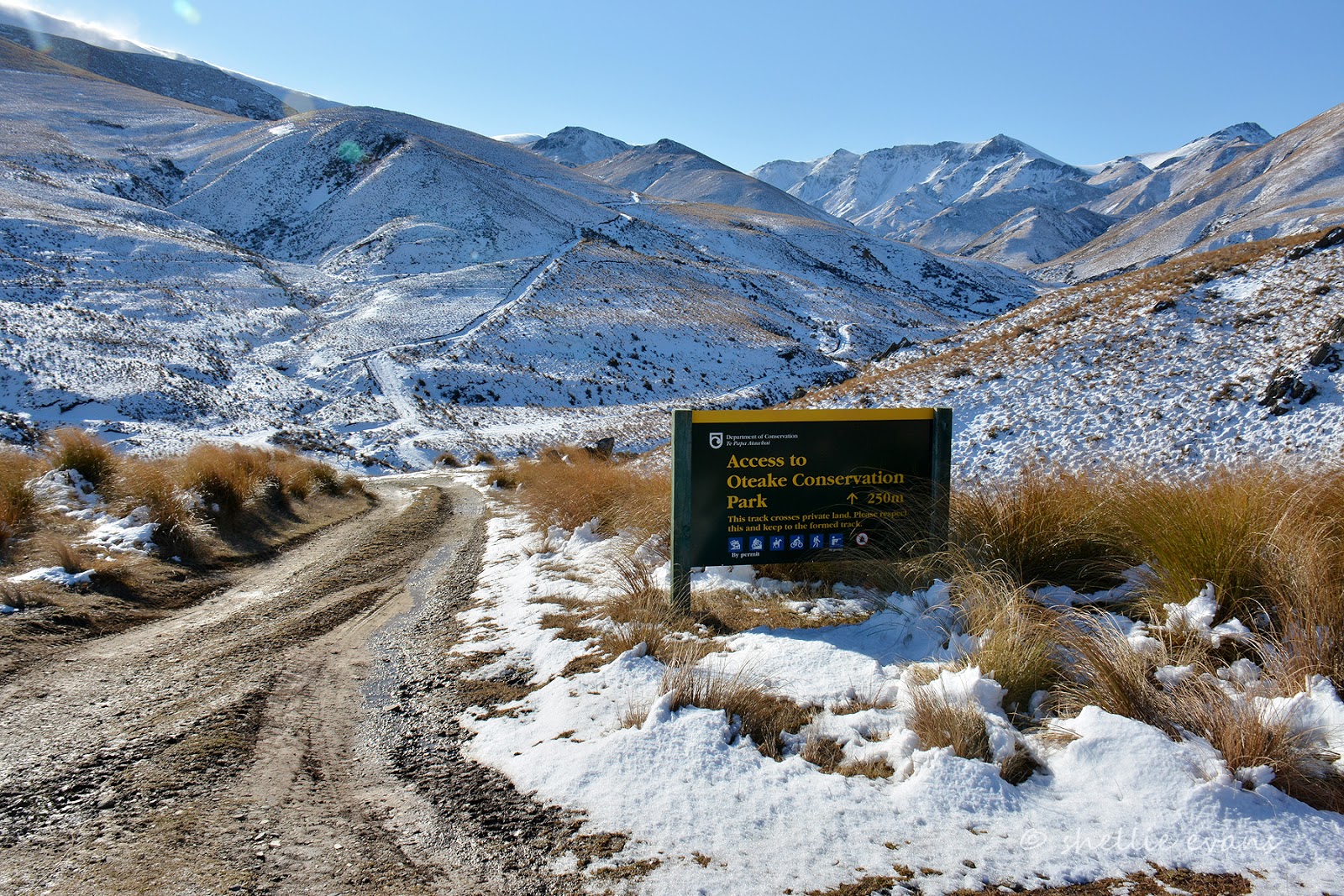
…and the Oteake Conservation Park, a huge & remote area where you can tramp, camp, mountainbike, 4WD and even horse ride. When it’s not winter. The park includes part of the Hawkdun & Mt Ida Ranges and stretches back towards St Bathans and over to Kurow in the Waitaki Valley. What an amazing place it would be to explore, you can download the DOC map here if you’re keen.
The road got a little narrow and rough in a couple of places and we hit a few icy patches as we climbed gently higher.

In a couple of places the rough schist walls rose vertically from the road and even appeared to overhang it a few areas, obviously the reason larger vehicles would have trouble negotiating their way past.

The view back down the valley over the snow tussock was stunning and we were thrilled to spot a NZ Falcon/Karearea chasing it’s lunch, a smaller bird, past us at very high speeds as they both weaved, ducked and dived their way down the gully on the right. It wasn’t going to be our last sighting of a falcon that day either.

There were some interesting schist rock formations along the road, this one looked as if it had just been pushed off the side.

At another stop there are some old bridge abutments. More than likely they’re left over from the original track through the pass used by teamsters and their wagon trains plying their trade between the Waitaki Basin and the gold fields of Central Otago.

Heading towards Mt David (good name) and luckily the snow on the road is more slush than ice….

And just as we’re thinking the snow better not get any thicker…

…we arrive at the summit- Danseys Pass, 935m.

We decide this will be as far as we’ll go, it’s mid afternoon and freezing cold outside with a stiff wind blowing. We don’t want to be caught on the wrong side of the Pass when everything starts to freeze up as the sun drops. We didn’t quite join the link, we probably only had about 12kms to travel down the Waitaki side to meet a point where we had travelled to last year when we were checking out Duntroon & Earthquakes (yes a settlement with that name). Perhaps we’ll travel up the Waitaki side of the Pass another time when we’re in that area.

A panorama from Danseys Pass, looking out over the Waitaki Basin towards the Pacific Ocean with the east coast, between Timaru to the North & Oamaru to the south, in the distance.

We have a quick cup of tea and a bite to eat while jumping about trying to keep warm before heading off back down the Pass towards home…

…with one final stop near the river at Kyeburn Diggings to watch thousands of finches feeding in a paddock of stock feed swedes and where we were to see our second falcon of the day. But you’ll have to wait for the next post to see that.
While at Kyreburn did you visit the farm where the gowns from the B&H Fashion awards are on display. They may be now displayed in Naseby. There was talk of a shift when we were there. There is something for David as there is a great display of Jim Beam collector bottles. Worth a visit.
ReplyDeleteRobin
Hi Robin- Look, I need you to tell me these things before we get there! :) Sadly I did not know about the B&H Fashion gowns being on display, although going by how deserted the whole Maniototo was on our visit I doubt it would have been open. Naseby was a ghost town too- museum not open, i-Site not open, library in historic church not open but then the more important places were- the pub & the coffee shop! Would have been good to see the Jim Beam collection too. maybe when we're back there in the summer.
DeleteNote that Duntroon is NOT in Canterbury, it's part of the Waitaki District which is North Otago!! Canterbury is finitely the other side of the river.
ReplyDeleteThanks for your comment Bernice, I love your fierce parochial view but my sources suggest that it's incorrect, here's what I found - Duntroon is a small farming town in the Waitaki District of New Zealand's South Island. Although traditionally considered a North Otago town, it is located within the farthest southern reaches of Canterbury. Just north of the town is the Waitaki River that forms the traditional border between the two regions, although the official border has now been moved south to put most of Waitaki District within Canterbury, including Duntroon- from Wikipedia.
DeleteBut then we know that Wikipedia is not always correct so I googled some more- Statistics NZ & Localcouncils.govt.nz also put Duntroon in Canterbury.
Although I'm very diligent in the research for my blog posts, I'm aware this doesn't make me infallible.
I am a relative of the Meikle family in the article above and my Mother always got very upset talking about this tragedy.. Shows how fast the weather changes in the back country in NZ
ReplyDeleteThanks for your comment & a link to a tragic event. Always sobering to realise that these tragedies happened not that many generations past.
Delete