
White Bay is a gorgeous wee bay surrounded by bush with a large DOC campground and we were the only ones there.

I did a ‘here’s where we are’ blog post on Whites Bay at the time, here’s the link which has more photos from Whites Bay including the possum that climbed the tree above our van.

We’d been waiting to explore the Port Underwood Road since we stayed at Whatamango Bay last October. Whatamango is at the other end of the road close to Waikawa Bay & Picton. We opted out of Whatamango after a day and didn’t get a chance to drive the coast road.
We’re now exploring the road from the other end, beginning at Whites Bay, and have about 50kms of narrow winding gravel road to drive (80kms for the round trip), climbing up and over sharp ridges and winding down & around beautiful tiny clear bays.
The first lookout point is looking out over Cloudy Bay (of wine fame) towards the entrance to Port Underwood on the far left, Cook Strait in the middle ground and the North Island on the horizon. There’s a distinct line of froth and colour that runs out from the coast, I’m not sure, but I think this is the meeting of the deeper cooler water of Port Underwood and the Strait meeting the discoloured warmer water of Cloudy Bay.

Looking south you can see the discoloured water entering Cloudy Bay near the cliffs in the background, this is from the huge Wairau lagoon and river system and the recent heavy rain- the rain that plagued us for a week at Momorangi. Once again we can see Clifford Bay, Cape Campbell and the lighthouse in the background (last seen from Yealands Winery).

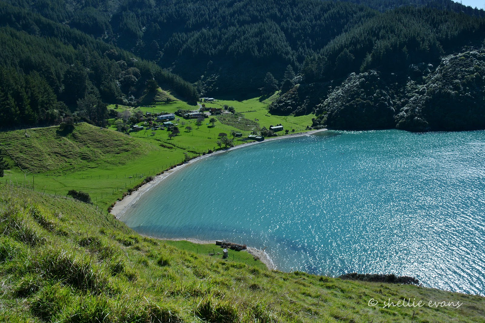
The first bay we stop at is Robin Hood Bay, where there’s a small DOC Campground (no fees) for tents and smaller campervans; it’s not recommended that larger vehicles drive the road although I’ve seen photos of big motorhomes lined up along the foreshore.

There were a few tourist vans in the camp and a couple of guys fishing from the gravel bank. As we pulled up, there was a lot of excitement with people running about trying to take photos, they’d caught a large octopus which they’d hauled in before it dropped to the stones and was making a hasty retreat back to the sea.

Here’s a panoramic photo of Robin Hood Bay taken from the northern end, it’s a bit distorted- I really need to get my tripod out to take these. This is 4 photos stitched together, to have it in proportion I probably need at least 10-12 photos carefully taken moving the camera on the tripod, inch by inch, across the scene instead of my rushed snap, snap, snap, join and patch! All the same, it makes a pretty picture.

At the end of Robin Hood Bay sits a historic cottage (with a new chimney), this ‘stud & mud’ cottage was built in 1854 for a whaling captain and his new wife. It is one of the four oldest buildings in Marlborough.

We climb out of Robin Hood Bay stopping at the top so I can take another photo looking back over it, you can see the DOC camp in the back corner behind the pylon and the road winding it’s way down the hill behind.

We round a corner and ahead of us up on a high point is one of the large pylons that track through the bush along the coast. Climbing over it are six men with paint tins and brushes, they look like ants from afar. You’d have to have a head for heights but what a view!

Further on as we start to wind our way down into another bay we come across three goats who had been grazing on the edge of the road (blurry photo but you get the idea). They take off in front of us, going hell for leather around the corners, left, right they run. As we appear around one bend they disappear around the next. We slow down hoping they’ll run off into the scrub on the side but no, they stick to the gravel. As they disappear around another corner we stop to give them a chance to slow and look for a gap in the bush. We wait a couple of minutes and then crawl forward, around the first bend, no goats, around the next, still no goats, around the third bend and there they are standing still in the middle of the road! They take off again, the road is getting steeper and they are running faster.

We stop again so I can take a photo looking down into Ocean Bay. Surely by the time we start rolling they’ll be gone this time.

Nope! It looks like Mum & the kids are now having a lunch break! We slowly approach them and away they race again. We can see that they have collars & tags around their necks so they either belong to someone up the top of the hill or someone down the bottom. Either way they’re along way from home. We speed up to try and force them into the undergrowth as we pass but no, the sides of the hill are too steep, up and down. Finally after at least a couple of kilometres we come to a sharp elbow in the road and they head off into the trees. I wonder how long it took them to walk to the top of the hill because I think they bet the downhill speed record for goats, coming down. And I thought sheep were crazy.

The road runs very close to the water in Ocean Bay, I’m sure it would get a pounding in a strong easterly wind. There’s just a woolshed, a couple of farmhouses and this old whaling pot in the bay. There were many whaling stations along the Marlborough coast during the 1830-47 whaling era, the whales passed close by on their migration north through Cook Strait to warmer waters.

At the top of another ridge I spot a sign post pointing out over Port Underwood to an island across the water. There is no other information which is a pity for passing tourists as I’m sure they wouldn’t know what it was for or why it must be important.

I have a brochure to tell me and our TomTom map also mentions why this is a very important island. When I zoom in on the island I can see a white plaque on the island’s headland obviously marking the spot of the Treaty of Waitangi signing. The island is also an old Maori Pa.

The next bay is Kakapo Bay and it’s where the first shore based whaling station in the South Island was built, by John Guard.
John Guard was a former Australian convict, his son John Jnr was the first European child born in the South Island. His descendants still own the land here and the cemetery (private & no access) holds members of the whalers’ families.

Tom Canes Bay is one of the more charming little bays along the road and there is public access to the waterfront too. A narrow vehicle track leads down between iconic kiwi baches to waters edge.

A large reserve with picnic tables & a loo are to the left in front of the baches and a narrow track leads around the water to another table under a tree on the far side. What a treat, we decide to have lunch here, sitting in the winter sunshine soaking up the scenery and peace & quite with not another person in sight. Although a nearby van & empty boat trailer remind us that we’re not alone. We often comment on what the rest of New Zealand might be doing while we’re having lunch in the most perfect setting…..we just feel so lucky and we never take our life-style for granted.

The last bay before we head inland over the range to Picton is Oyster Bay. Oyster Bay! Another favourite wine of many but I’m afraid not a vineyard in sight.

Oyster Bay was also another on-shore whaling station and is now a safe boat harbour and wharf for the many fishermen and mussel farms on this side of the Sounds. This house boat was tucked into the side of the bay, it looks like a small car under the cover but I think it’s more likely to be a BBQ or spa pool perhaps; one day when we’ve finished exploring the land we might just find us a house boat to hire for a few months to explore the Sounds.

We climbed up out of Oyster Bay and stopped for one last photo looking back over Port Underwood where we can now see Horahora Kakahu Island in the centre, protected from the wilds of Cook Strait by the finger of land that forms the other side of Port Underwood.

It was about here that my head won out and I decided we didn’t need to travel a 28km round trip on another narrow gravel road towards that finger to see a memorial. We continued on over the range, the road turning to tarseal not long afterwards, to complete the 80km loop back to Whites Bay via Picton. Another interesting and informative day with some stunning scenery.
Thank you for sharing all the info and photos. We enjoyed looking and may, one day, follow your route. We wouldn't be brave enough without seeing this post.
ReplyDeleteThankyou Cynthia, much appreciated and I'm pleased the post may have helped you decide to drive the road. While it is very winding and narrow it's not too bad and not the worst road we've traveled. I would choose a week day though, when there's likely to be a lot less traffic.
Deletesuper cool ..great post
ReplyDelete