Showing posts with label butchers dam. Show all posts

July 26, 2015

Flat Top Hill Conservation Park

We’ve not done much exercise in the last couple of months, we've been blobbing it a bit, both because of the cold and the fact we’ve been enjoying just being parked up and relaxing with the family.


So  I was thinking we’d ease back into it, it was such a lovely day we’d walk the Butchers Dam Loop, an hour long walk at the back of the dam that took you a little higher up the hill so we could see the whole lake.


I mentioned that I’d love to walk to the top though,  because I was sure that we’d be able to see the Clutha River Gorge over the other side. So it was a nice surprise when David said “Let’s go!, we'll walk to the top” So we set off along the Basin View track which initially followed a 4WD track west along the base of the hill, slowly climbing.


Looking back we could see the dam wall and the lake with ‘Out There’, way over the other side. We got a bit of a fright when we saw a car pull up beside the van, it’s an awful feeling seeing someone near your vehicles and knowing that there was nothing we could do if they had ill intent on their minds. We breathed a sigh of relief when they walked off after awhile, with a dog bounding ahead of them. I don’t know why we got a fright, we leave the vehicles all the time and have never had an issue. I think it was because we could see them.


The 4WD track wound it’s way in and out of the gullies and seemed to go on forever, around every bend we thought we’d turn to start the climb up the ridge. In the end David decided a short cut was in order. Especially when he saw a line of sparsely placed small white pegs with a tiny blue ribbon attached, weaving their way up the side of the hill beside us. After a bit of a discussion and a check of his tracking app, we decided to follow the white pegs and cut off the corner of the hill.


I don’t know what the pegs were for, perhaps for a yet to be cleared mountain bike track (mountain biking has only recently been given permission to form tracks over the hill), or an orienteering course or maybe a cross country race, but we carefully followed them up the hill, around and through the many rock piles and over the dried thyme which gave out a fragrant smell as we disturbed it. For a non-native plant it’s certainly made itself at home, it covers nearly every inch of space for as far as the eye can see.

We’re climbing higher and the dam is getting smaller and our van is still in view…with no cars parked nearby.


After the initial steep climb the ground levels out a little, the white pegs disappear and we’re still not back on the main track with the DOC orange marker poles to lead the way. I spot a white stick with no blue ribbon far up to the left but David thinks we should go to the right (which is the way we'll be heading when we do find the top- he's keen to shorten this walk some more). We beg to disagree and he heads off on his own to the right, I head to the left and pick up the peg trail again just below the outcrop of rocks on the left ridge.

We weren’t too concerned as either way we had to reach the top of the hill and the track soon- anyway I wasn’t going to starve, I had the food, all he had was my tripod and a thermos of hot water!  But seriously, I can see how people get lost out tramping in groups, especially if they disagree with a direction and head off on their own course.


I made it to the DOC track first but had to walk further, as I came around a peak I could see David ahead of me, beating his way through the briar bushes.


We were finally on the track and heading for the top, I turned around to check out the view to the north, towards the Maniototo, where we’ll be heading next. Far off in the distance are the snow covered Southern Alps. It’s a bit hazy, a photographer I spoke to at the dam earlier in the day told me there was a big burn off on one of the stations and the whole valley was covered in a smoky haze.


We found a view to die for and a large flat rock to sit on to have our lunch before the last final push to the top of Flat Top Hill. SH8 (Roxburgh to Alexandra section) can be seen running along behind the lake and up behind is the snow covered Old Man Range. No wonder this walk is called the Basin View.


After lunch, refreshed and refueled, we headed off again, the track nice and level for a short distance…


…before we pass a vehicle track that heads off back down to the lake and David is tempted to take it when he sees how steep the last section to the top is. I tell him there’s no way I’m taking. After coming this far, I want to see if the Clutha River is on view when we get to the top. He decides to stick with me. It’s a tough haul up the rutted track, not least because it’s turned into a bloody hot day and we have winter clothing on.


Finally we are rewarded, the Clutha River snaking it’s way down the gorge from Alex. I’d love to see this view in the autumn when all those willows along the banks would be in their autumn colours and the river a brilliant turquoise. That’s a walking track along the other side of the river and part of the Clutha Gold cycle track runs along this side of the gorge in the shadow.


There are some amazing rock formations all over the hill, from stacked rounds of schisk piled on top of each other to slivers that look to have been pushed sideways.


The track passes close by a rocky outcrop that drops away into the gorge below. It’s a pity we left our run a bit late and the sun is leaving the riverbed. This is looking east towards Roxburgh, the cycle trail can be seen more clearly in this shot. It may not look like it but it’s a very long way down there, I doubt you’d see more than a black dot on the path if anyone was passing by.


I wonder how the rock finds its way to sticking up like this.


David’s getting weary, and impatient to find the track back to the dam, he leaves me in his wake. Which isn’t hard when I keep stopping to take photos.


We pass a cutting in the rocks and can see straight down to the lake….and our van again. I’ve zoomed in quite a bit here. There’s no way down through this section, we have to carry on along the ridge.


Finally we find a road going virtually straight down, we can see another sign a few hundred metres further on and looking through the binoculars and checking the tracking app we see that it’s the walking track to the bottom but it wends its way back and forth down the steep hill taking all the steepness out of it but probably doubling the distance to walk.


We decide the Haul Road will do us so off we head, down some very steep sections, we skid on the loose gravel and try not to let our feet get away on us. By about half way our toe tips and knees are complaining, it reminds me of walking down the Key Summit track on the Milford Road.


It took forever to reach the bottom, and even then we took a short cut when the track headed off in the opposite direction before reappearing at the base of the hill. Six kilometres and three and a half hours later we arrive at the lake edge and head for home passing the remains of Lye Bow, the Chinese gentleman’s cob cottage on the way (see the previous blog for details).


Maybe next time David will listen to me when I say we’ll ease our way back into walking.

From DOC-
The Flat Top Hill Conservation Area consists of 813 ha purchased by DOC in 1992. Situated behind Butchers Dam, it encompasses the northern end of Flat Top Hill running north to south, bounded by Lake Roxburgh in the east and Butchers Creek and State Highway 8 in the west. Flat Top Hill is a miniature block mountain, at the foot of the Old Man Range (Kopuwai). 
A dry land ecosystem, Flat Top Hill supports a diverse range of animal and plant life, including examples of regenerating native plant species that previously covered much of the lowland valleys of Central Otago. Dry land ecosystems are one of New Zealand’s most threatened ecosystems. Flat Top Hill is important for observation, recording and management of such ecosystems.
The area also includes some interesting historical evidence of European and Chinese settlement.

July 24, 2015

Frozen

Our arrival on a balmy afternoon at Butchers Dam was followed by a frost overnight…


…and an amazing sight to wake up to – well, amazing to this North Islander who has never seen anything bigger than a puddle freeze over. The dam, while not totally frozen, had a large covering of ice over the centre and around some of the edges. I wondered why it hadn’t frozen on our edge as it was very shallow. And while it was a -5 degree frost it didn’t actually feel that cold outside, and yet cold enough to freeze the top of a large body of water.


I waited to watch what the sun rise did to the snow capped Old Man Range, first the sky turned a beautiful mauve hue as the pre-dawn gloom brightened…


…and then as the sun rose higher & crept down the snow, the colour turned a beautiful pink…


…..until finally it reached the bare poplars & willows turning them the rich rustic colours of the golden hour. You can see the iced over sections in the middle of the water.


Across the partly frozen dam the western face of Flat Top Hill stayed in the shade while the willows and bull rushes came alive.


The midday sun failed to melt the ice….


...although it had retreated a little….


....but by 4pm the temperature was dropping again which meant the ice was here to stay.


The next morning there was a glorious sunrise and another surprise in store….


A much heavier frost, minus 7 degrees….


….and the dam frozen right to the edge. Of course there was no way I was walking on it, it was no more than a thin coating but I had fun tapping the edges and watching the ice crack away and spread ripples out under the unbroken ice.


The thick layer of cloud that rolled in just after sunrise stayed put, casting a cold grey pall over the lake.


Flat Top Hill looks very uninviting across the water, luckily we did a walk up there in the sunshine yesterday (a post to come on that shortly).


I took a walk around to the dam wall, passing these rocks which, over the last couple of days, a pair of oyster catchers and a large shag had been jostling for ownership of. I wonder where they have gone to now, especially the shag probably up a nearby stream. It must be lean pickings in the winter.


The movement near the overflow hasn’t frozen, nor a couple of sheltered coves.


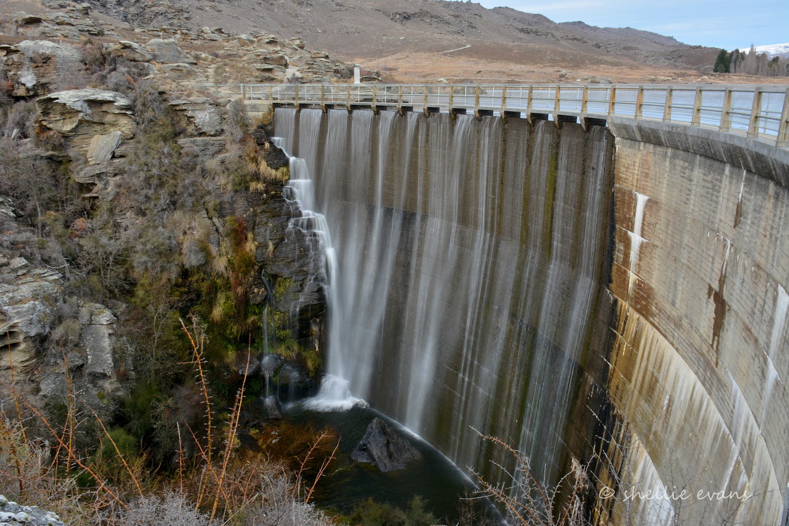
At least the cloud cover allowed me to take a decent shot of the dam wall, the shots the day before had harsh shadows. Just a pity I left my tripod back in the van. Oh well, a steady 'one foot forward, elbows tucked in, don’t breathe’ stance allows me to slow the shutter down (and not fall off the edge!), to make the waterfall silky smooth.


And for those that are interested, the settings for both these were-
ISO100, f/22, 1/4 sec shutter speed.


What a difference,  it’s hard to believe this is the same place we arrived at 36 hours earlier. And I suspect had we arrived when it looked this uninviting we would have carried on and found another place to stay. Which would have been a pity, look what we’d have missed out on. Never judge a book by it’s cover.


July 23, 2015

Winter Beauty- Butchers Dam

Yesterday morning, after nearly five weeks parked in our Winton family’s driveway, we headed back ‘Out There’. We were sad to be leaving but we know we’ll be back down south in the summer so it won’t be too long before we see them again.

We had an awesome time, lots of laughs, a few surprises and thoroughly enjoyed spending time with Ollie & Ruby especially as the last two weeks were school holidays. It’s great to see that the family have settled into Winton well after shifting from the ‘big smoke’ Invercargill.

I’m afraid we wouldn’t enjoy the winters very much if we had to live that far south though. For at least the first three weeks we had minus 2-5 degree frosts nearly every morning which wouldn’t have been so bad had the day warmed up to something above 5 degrees. At least the sun shone brightly every day. And then the snow came, but that was definitely a highlight. Although it refused to melt for nearly a week which shows you how weak the sun’s warmth was.

I think we’ve jinxed Southland; on the first visit we spent 5 weeks in Invercargill over Christmas & New Year (2013-14) and it blew a howling gale and was freezing cold for all but 3 days and everyone said it was the worst summer they’d seen. This time it’s five weeks in Winton and everyone said it’s the coldest winter they’ve ever had, never mind the dump of snow. Oh, and in between we made a special trip back to attend the Bluff Oyster Festival. Well we know what happened there- we got evacuated when a storm blew the marquee apart. And hail fell on the ground at the campground two inches thick! Hmmm…perhaps we’ll meet the family on neutral territory next time.

We left Winton just as the heavens opened up and it was a wet and gloomy trip all the way through to Gore where we stopped for lunch. Blue sky arrived as we crossed into Otago and by the time we arrived at Butchers Dam it was a relatively warm late afternoon, even with a solid coating of snow along Old Man Range behind us. Butchers Dam is 9kms from Alexandra in Central Otago.


Butchers Dam was built between 1935-37 during the great depression for an irrigation scheme, as were many dams in the Central Otago area. During the 1860s Butchers Gully teemed with gold mining activities and up to 150 people lived in the Gully. Most of the mining took place in the basin that is now the reservoir behind the dam.

A store, butchers shop and hotel were set up in the gully during the 1860s. The hotel was destroyed (by fire) and replaced twice before the last hotel was built in stone in 1890. This hotel was submerged under the reservoir in 1937. It is said that when the water is low the chimney stacks can be seen below the surface.


The remains of a stone cottage belonging to a well know and generous Chinese gentleman, Lye Bow, is located in the poplars across the dam. Initially he mined in the gully during the 1860s, then went on to purchase land and planted the first apricot orchard and market garden in Central Otago.


Butchers Dam is a well known freedom camping area, there are any number of spots to park along the west and north ends of the dam tucked in and around the small coves. It’s a busy place during the summer but all we have for company are the rabbits and a few hardy birds.


It was autumn when we last passed the dam (we didn’t overnight then) and the poplars and willows were stunning in their brilliant autumn colours. One of my photos of the dam then is the cover photo of the NZMCA member’s handbook. But as you can see every season has its beauty.


The owners of the dam allow access across the dam wall to the  Flat Top Hill Conservation Area which has a number of walks around and over it and forms the backdrop to the dam. It also forms part of the Clutha River gorge on the far side.


The dam wall is 24 metres high and 69 metres along the top.The concrete arch varies in thickness from 762mm at the top to 2.7 metres at the bottom. The far half of the dam wall is slightly lower allowing excess water to spill over, falling onto a series of rocks to break up the energy on it’s way down so that the dam base and creek bed are not worn away.


The day’s end at Butchers Dam. Tomorrow we will tackle Flat Top Hill.


May 16, 2014

Only a Face a Mother Could Love


Meet Horace & Horatio, two very friendly & comical looking 12 year old kunekune pigs who live in a paddock beside our next camp site in Clyde, Central Otago. The mornings were cold & dreary for our stay & these two mirrored their human neighbours; not surfacing from their warm & cosy hut until very late in the morning. And then only to look for food and a scratch …... hmmm…...


Kunekune in Maori means “fat & round” and these two certainly live up to that description. Kunekune are very sociable, placid pigs and love close human contact. They are intelligent and affectionate and are a unique New Zealand breed of pig. Their characteristic shape is short-legged, short snouted with high fat which gives them their rotund look. Although these two looked like they had raided the cookie jar a few too many times. Kunekune also have neck “tassels”, a small tassel of skin that hangs off both sides of the jaw. These two had them but they were hidden in amongst the bristles & folds of fat.


\
In early times Kunekune pigs had a close association with Maori, they tended not to roam & were valued for their meat & fat, the fat being used for preserving food. The breed was “rediscovered” in the late 1970s when there was estimated to only be 50 purebred kunekunes left in NZ. Since then the numbers have built up into the thousands, many of them kept as pets which suits their friendly nature & small statue.

Every day Horace & Horatio with their friend Lambie, a Whiltshire Pole sheep (they shed their wool), went walkabout from their yard, across the ground where we were parked and over to another yard behind a shelterbelt where they spent the day close to an orchard accommodation block and the workers who lived there. And more importantly near the cook who no doubt supplies titbits throughout the day. As soon as the gate was opened they were off, just one thing on their mind; and if there happened to be a fifth-wheeler parked across their route, no matter, they walked right on through, over the mat and through the gap between the van & ute much to David’s consternation!


Even when the “cook” stopped to talk to us they carried on, disappearing through the trees well ahead of her. And in the evenings back they came at a full trot ahead, this time because they knew she had their dinner with her. The lamb just followed the cook wherever she went, even down to the river for her daily walk, back & forward the motley procession paraded twice a day.


We had arrived at the CAP(costs apply parking) after leaving Lowburn on a wet, cold & dreary day. CAPS are properties that allow members of the NZMCA to stay overnight or for a few days at minimal cost (this one cost us $5 a night) and along with POPs (park over properties-no fee), there are hundreds located around NZ. They offer a secure & safe site to stay, often with extras like water, internet & laundry etc. We’ve found some great places to stay in our travels and always look forward to our next CAP/POP although often with a little trepidation as “you never know what you’re gonna get”

On our way through to the CAP site we stopped at the top of the Clyde Dam, the largest gravity dam in New Zealand.


The Clutha River was dammed just above Clyde and this section now forms a very long arm of Lake Dunstan. After much controversy the dam was completed and in 1992 the fill began. The gorge that was once “wall-to-wall” with people during the gold rush and more recently lined with orchards & farms, houses & pubs, roads, bridges & train tracks is now flooded with very little to remind people of its past.


Unfortunately it rained and the cloud hung low on both the days we stayed in Clyde so I was unable to  get any decent photos of this historic town. The last of the autumn colour was the only bright spot in an otherwise dismal couple of days.

Looking back up the Clutha to the dam wall from the Clyde Bridge-


Another red bridge over the Clutha, the steel arched Clyde Bridge was built in 1934 after the orginal wooden structure was swept away in 1878, just two years after it was completed. Only the cable & stone piers were left, the cable piers were removed but this bridge rests on the original stone piers.


Below is a small selection of the historic buildings dotted about the town of Clyde. We stopped in town for lunch, which we had in a café that has taken over the tiny former BNZ building.

Top left- Post Office 1865, the original Post Office was a calico tent, then corrugated  iron & wood before being replaced with this building in 1865.
Top right- Dunstan Times Building 1866, Clyde was the brithplace of the Goldfields Press with its first publication in 1862.


Bottom left- Henry Wong Gye’s house circa 1870s; married an English woman & had 14 children. Henry was fluent in English & a special constable with responsibility for the Chinese miners.
Bottom right-Tyrell’s House, a very old stone house, thought to be the earliest one built in the town. Mr Tyrell, a clerk of the court, built it for his family in the 1860s.

Unfortunately the weather wasn’t very conducive to doing much exploring of the Clyde & Alexandra area but no doubt we will be back in the area again during our travels and next time we will stay a little longer and venture further afield. We did take a drive down to Alexandra where we crossed another bridge over the mighty Clutha, this time the bridge is painted a beautiful powder blue. I'm now collecting Clutha River bridges!


The remnants of the old Alexandra suspension Bridge stand beside the new, I doubt whether any modern day vehicles would fit through the arches if it was still in use. Just below the bridge one of Clutha’s tributary rivers joins the flow and after the rain it is a dirty brown, here the weather has yet to affect the beautiful aqua colour.


We drive east a little way to check out Butchers Dam which is a free camping area where we thought we might  stop for a night or two. The area is beautiful, surrounded by wonderful schist rock formations and the golden colours of willows, reeds and grasses. It’s a little exposed to the main road traffic and also there is a lot of mud around so we think we’ll give it a miss this trip. There’s good trout fishing to be had in the dam and also a few DOC walks so I’m sure the place will look a lot more welcoming next time we pass through.


The next day when we passed I stopped to take this photo of a motorhome parked up below the road, it had dried out a little but the tracks in were still slippery & wet and we’d decided to head on to Pinders Pond just south of Roxburgh.