March 24, 2015

Westport- Beach Park & Tractor Trekkers

Just to let those that eagerly await my next blog post know, unfortunately cellphone & internet reception will be intermittant over the next few weeks as we travel the West Coast so there may be a few more days than usual between posts. 


The NZMCA (NZ Motorhome & Caravan Association) has over 50,000 members nationwide who are entitled to many benefits and perks including heavily discounted Cook Strait ferry crossings, discounts with a major appliance & electronics store and various other discounts elsewhere. The Association also has 27 NZMCA Parks located around the country in some stunning locations. For a very small fee ($3pp per night) members can stay in a safe & secure environment for anything from 3-7 nights per month depending on the park. Some parks have a dump station, laundry, most have rubbish recycling & fresh water. They are a Godsend for us and we always enjoy our stays.

I was a little worried as we followed the co-ordinates that I’d entered into TomTom for the Westport NZMCA Park. They led us through town and down towards the beach, onto a bumpy gravel road, past a swamp and rough scrub and out onto a sandy parking area that looked like an afterhours meeting place for the local hoons- in fact they used the wide expanse of beach at low tide to ‘hoon’ down. Freedom camping is allowed in this area and most nights there were half a dozen vehicles parked up. 

Down to the left of the sandy carpark a gravel road led to a large enclosed area with a firmly packed gravel surface and a locked gate; the NZMCA Park. What a great spot, right on the beach and only about 3kms from town.


The caretaker is obviously having a bit of trouble with visitors arriving at the park and not being able to get in even though they have the combination- I like his humour. I would have to admit though, that unless you read the sign board (and you don’t if you’re quite familiar with the routine) then you can get pretty frustrated trying to crack the code. And I would think you’d be especially peeved off if it was pouring with rain. Most combinations line up with the centre line on the padlock, not a top one (I didn’t even know they had a top line). While we were there (4 nights) at least 80% of arriving vans had trouble getting in.


But in the end it is worth the hassle, there’s not too many places where you can park up overnight so close to sea and watch the sun set below the horizon while you’re cooking dinner (or having a glass of wine).


I do think the caretaker should put up one of these signs though, 4 or 5 very friendly weka spend their day cruising around the park, resting under vans and fighting each other if someone throws out some food. Which is often.


As you can see the Park is a pretty popular place, most people using it as a base while they explore the top end of the West Coast. Those with caravans & fifth-wheelers were able to leave their vans in place while exploring each day; the motorhomes & buses had to take pot luck and find a new position when they returned each evening.


The beach was also popular with the Kiwi Experience tour bus. On our first night I heard a whole lot of chatter and laughter and when I looked out the side window a crowd of young people carrying supermarket bags of food plus wine & beer were walking along the fence line past us and over to the beach. They gathered up some driftwood and added it to a already charred fire pit, lit a bonfire and partied on for the next couple of hours. Now that’s a real “kiwi experience”. The same thing happened the next night but they were a little later and missed the sunset. The next night it was raining heavily.


It was a great surprise to find some friends from Tauranga parked up just along the fence from us. I was walking across the park and saw a couple of guys talking, as one walked off towards his motorhome I thought he looked familiar. I called out to him but he didn’t hear me and disappeared around the side of the motorhome. I was sure it was Ian so I followed him around the side calling his name. He still didn’t hear me and for a moment I thought I’d got it wrong but then he turned and saw me, and then Jess appeared at the door.

It was wonderful to see them. We had a couple of very happy ‘happy hours’ for the next two evenings and caught up on our travels, & gossip from ‘home’. It is rather strange that had I not seen Ian we could quite well have not known each of us were in the park. We often don’t see our neighbours as everyone comes and goes each night & morning.


The town of Westport is nothing to write home about, it’s your usual small provincial town (pop. 4000) with not much to offer. There’s a short main street with pretty hanging flower baskets on each side which add a bit of cheer, a number of restored historic buildings & plenty of empty shops and shops selling tacky imported junk. There are no decent clothing stores but a good number of cafes and a large i-Site that is always busy- tours leave for the coalmines & up the coast from here.

And then there is the most beautiful Municipal Chambers (former) building I have seen on our travels. It is absolutely stunning. It was built in 1946 and is coated in Motueka sand which gives it this beautiful colour- remember the sand from our time at Kaiteriteri? The Phoenix palms are the perfect accompaniment to the Art Deco style.


And what better place for a procession of tractors towing various forms of accommodation to be welcomed into the town. The convoy, 27 in all and called the Tractor Trekkers, are towing a range of pop-tops, caravans and wooden sheds around the South Island raising funds for the Westpac Chopper Appeal.


They were on their way to Karamea (at the end of the road) before returning to Southland (where they are from) via the east coast.


We passed them two days later as they were returning from Karamea, spread out like Brown’s cows along the highway. Which was just as well as some were moving along at a cow’s pace.


Sunset over Westport’s NZMCA Park.


March 21, 2015

Lyell- The Old Ghost Road

Our next overnight stop after Murchison was the DOC camp at Lyell in the Upper Buller Gorge.


Gold fever swept through this area in the 1870s and Lyell was once a booming settlement serving the gold mines in the area. Now the junction of the Lyell Creek and the Buller River is a popular DOC camp.


All that remains of Lyell and the settlements of Gibbstown, Zalatown, 8 Mile, & the Alpine Battery which were inland from the Buller River, is the old dray road that connected them all, the remnants of the Croesus Battery with other gold mining relics scattered about and the remains of Lyell Cemetery.

The dray road is now part of an 80km three day cycle & tramping track that starts at Lyell and finishes at Seddonville on the coast, 50kms north of Westport. Historic mining pack tracks form each end of the The Old Ghost Road with a difficult alpine section for experienced trampers & bikers in the centre. Going by the number of bikers we saw in the short time we were there, the track is very popular, although most only do the first section up to the Lyell Saddle.

I walked a short 4km loop to see the old battery and the cemetery. It’s amazing to think that there were houses, hotels & a bustling community living along the edge of the deep gully where the gold bearing Lyell Creek runs. Now it’s all native bush and birds.


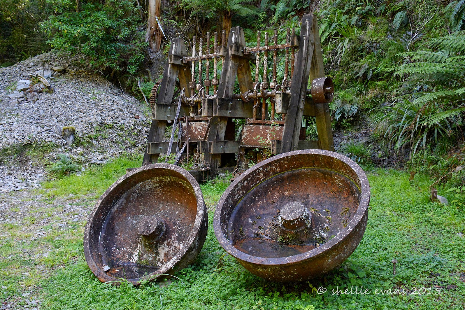
At the end of my walk are the remains of the Croesus Battery including two berdan dishes, which revolved to crush the gold bearing quartz using heavy steel balls, and various other rusting relics from the gold mining days.


I took the above photo from a platform where there are information panels about the site and also a sign suggesting people not venture down to the remains. (Click on the photo to enlarge to read)


I decided I wasn’t going to walk 2kms to see the battery and not get up close and personal with it. Many others must have thought the same, there was a well worn track down to the creek bed.


After having a scout round I climbed back out of the creek bed and returned back along the same track. Half way along, a well worn track dropped down to the creek again, There weren't any signs saying where it led to but I was hoping it was going to be to the cemetery. I had a map but not my reading glasses and the tracks on the map were so tiny I couldn’t see where it ended up.

Problem solved! I zoomed in with my camera, taking a shot and then blowing that up on the LCD screen.  It would seem that I should have walked the track in the reverse direction, hence the reason there was no sign pointing to the cemetery. Although I think they still should have had one for directionally challenged people like me.......although I wouldn't actually say I'm directionally challenged. In fact I'm actually pretty good- I'm my father's daughter afterall, there's no denying that. It's more about not following the norm, I'm like a bull at a gate sometimes. I should have walked up to the top level and read the sign and map board up there instead of the biking and hiking 'Ghost Road' board on our level.


After a tough climb up the other side (another reason the walk started from the other direction) I finally came to the picturesque Lyell cemetery tucked into the bush.


Clinging to the hillside are a few surviving grave sites & headstones, in iron-fenced plots….


….with large trees growing out of some of them and in one case a fallen tree crushing the iron fence and knocking the headstone aside.


The headstones tell stories of short lives and tragic deaths, between 30 & 40 people were buried here from 1880 to 1900.


I pity the poor people who had to cart the newly departed to the graveyard, it was a fair hike along another ridge back to where the town (camp) was located.


Along the way was this gorgeous emerald green moss and fern covered rock face with a tiny little trickle of a waterfall, water seeped through elsewhere keeping the mosses moist and vibrant.


By the time I got back to camp, quite a few people had arrived in their sleeper vans & tents and had set up around the perimetre of the campground, all trying to find a level site and most spending time flapping their arms about trying to dispatch the sandflies. We are so lucky to have our insect screens and good bug spray (Bushmans).

These weka can't count!


The next day we were back on the road heading for Westport, I was looking forward to driving through the beautiful Lower Buller Gorge and seeing the 'famous in New Zealand' prominent landmark of Hawks Crag for the first time.


We stopped at the Kilkenny Lookout (on St Pat's day no less) and then my ever patient husband left me there while he drove through the cutting in the rock wall…..


…then turned around and came back to pick me up, giving me ample opportunity of taking some great shots of the rig.


There is actually quite a bit of room above the vehicles but it sure doesn’t look like it when you’re in the cab.


He was chased back through by a petrol tanker who caught him up as he was doing a slow drive past for my benefit!


And here’s the view from the front seat. From the lookout the wooden pole looks like it’s supporting the rock overhang when in fact its quite a distance away from it. I wonder what its there for.


March 19, 2015

Volunteers Without Gumboots

That’s the terminology DOC (Department of Conservation) use for people that don’t necessarily get out in the ‘Great Outdoors’ volunteering their services for monitoring, trapping, weeding or planting. There's a whole host of volunteers contributing to conservation while staying warm and toasty in the office, at home or in their fifth-wheeler as the case may be (Gumboots, for my overseas readers, are Wellington boots).


About 18 months ago I was contacted by a lovely lady from DOC who had seen some of my photos on Flickr. She wanted to know if I’d be willing to let DOC use them in a brochure. One thing led to another and after thinking a lot about it, I decided here was something I could do to help DOC and New Zealand conservation. Rather than the physical work involved with the usual volunteering, the fact that we’re on the move most of the time and most importantly, because we spend a lot of time enjoying DOC’s hard work in the parks and walks we visit, I decided to give DOC access to as many of my photos as they wanted.


Over the last year or so I’ve been aware of the odd photo being used on information boards located out in the field and also in some of the new brochures printed for various walks etc.

But it is with some pride that I can report (I’m allowed to pat myself on the back aren’t I?), last night, after many months of hard work, the brand new DOC website went live and there, in over 300 places throughout their complex website, are many of my photos taking the prime banner position with many more in the small photos and albums linked to the activity or bird. Unfortunately I missed out on the opening home page banner but really, who could resist that cheeky looking weka! (You’ll have to click the DOC link below to see)

Above & below are a few screen shots I gathered together of some of my photos that were used. Even David makes an appearance on a few occasions. If you would like to check the DOC site out, here’s the link-

DOC- Department of Conservation


And if you type Shellie Evans in the search box in the top right corner you’ll be presented with a very long list of links that have my photos in them. Once the link is opened you can see who has taken the photo (me!) by clicking on the little camera icon showing at the top right of the photo. Of course the ‘camera’ icon in these photos doesn’t work, they are just screen shots from the actual website.


I’m thrilled to bits to be a part of the volunteer team at DOC and very proud to be able to do ‘my bit’ for New Zealand conservation. Of course I couldn't do it all without my best mate beside me; whether it's driving, carry the pack, finding birds, being very patient as I take shots or most importantly, being my walking buddy. Thanks darling for your contribution to NZ's conservation too!


March 18, 2015

Much in Murchison

We stayed at the NZMCA Park in Murchison for six nights in the end, relaxing, catching up on computer work & enjoying the small country township which was always busy with passing travellers; alot who stop to refuel both vehicles and themselves.

I mentioned in a previous post how hot it was, in fact it was extremely hot every afternoon that we were there. Low cloud and fog settled in the valley overnight so the mornings were always cloudy and overcast but by lunchtime it had lifted or burnt off and with not a breath of air, the sun was a scorcher! Our outside temperature gauge ranged from 32-36 degrees some afternoons. Inside wasn’t much better at 30+.

I got so distressed with the heat the first afternoon, that I went to the shop next door to ask the guy where the local swimming hole was. He directed me back up the road, past the cemetery, through the domain campground to ‘eel pool’, a deep hole on the edge of the Buller River. Not even the pool’s name was going to stop me from jumping in. And it was heaven! Another couple (workers from the pub) were also there, they were jumping off from the rocks, I was happy enough with my pool.


That evening, and for the next two, a massive thunder & lightening storm formed & then raged over the mountains to the north of us, luckily the rain didn’t reach down into the valley. Light from the sunset cast an eerily glow over the park.


We don’t eat out that much while on the road, we’re usually out in the wops or passing through towns but with Murchison having so many eateries (5 or so cafes, 2 pubs & one small restaurant- and this is a very small township) and with us parked just a few metres from them all what could we do? Let’s just say it was our contribution to the local economy. We had dinner at the pub (nothing to write home about), went to dinner (with some lovely people) at the Cowshed Restaurant, a tiny quaint 16 seat room on the side of a garage (great food).   And had breakfast at The Rivers Cafe (a very popular cafe) set up in an old service station, the outside seating was across the old forecourt. We also had morning tea at another couple of cafes and all served good & tasty food and all were very busy.


And who were those lovely people we went to dinner with? Jackie & Bob, David’s sister and husband! It was a lovely surprise to see them, our paths crossing just for the night. They were on their way back home to the Bay of Plenty (via Golden Bay) after catching up with their family in Southland over Christmas.


Whenever we’re on a remote walk beside a tumbling mountain river we’re always on the lookout for NZ’s rare & endangered endemic duck, the Blue Duck or Whio. So far we’ve not spotted any. So when we found out the the Fyfe River near Murchison has around twenty pairs of ducks along it’s reaches, it was an ideal opportunity to see if we could tick another native bird off our list.

The Fyfe River is located in a remote valley beside Mt Owen in the Kahurangi National Park. We drove up the winding gravel Owen Valley East Road for about 15kms before coming to a private farm which we had to cross to get to a track that skirted around the edge of a gorge that Fyfe River flows through. We knew we were in the right area, the familiar 1080 drop warning board had a Blue Duck photo this time, at the Lake it was a Kaka photo.

After driving over a rough farm track, opening and closing a few farm gates and startling the cattle & sheep in the paddocks as we drove through, we parked beside Frying Pan Creek. The track started just across the creek near a broken concrete ramp that saved us getting our feet wet- little did we know that we had dozens of water crossings ahead of us.


It’s the first time we’ve seen a dydimo ‘clean your gear’ station at the beginning of a track, although it would have helped if the detergent bottles had something in them. I think it’s a lost cause though, because this was a stream we crossed just a few hundred metres up the track- coated in filthy ‘rock snot’.


We followed the track through farmland for about 2kms, chasing a flock of sheep ahead of us all the way. Why they didn’t just run off the side I don’t know. We stopped occasionally to help ourselves to a few ripe blackberries although we were just a couple weeks too early to pick ourselves enough for a blackberry & apple pie, but the ones we did find were tasty & sweet. David started out in his track pants- it was overcast & cool when we left camp but by the time we started the walk the sun had broken free and was beating down on us yet again, he had to roll his pants up to try & keep cool. By the time we got home his trackies were covered with spikey biddy-bid seeds- both on the in & the outside! He then had to spend the next couple of hours picking them all off!


Eventually we entered the bush and started to climb & climb some more. The track narrowed and became more overgrown as we went on. We crossed the creek dozens of times, clambered over fallen trees and along slippery rocky walls. These photos are from the beginning when it was an easy climb. It was a beautiful walk, brilliant green mosses and ferns smothered the ground and trees and the bird life was amazing.

In the end I had to put my camera away in my backpack(a first!)- hence no photos of the tough terrain, that and the fact that it was very dark in the bush and we really had to watch our every step. After an hour or so of tramping and hauling ourselves through the undergrowth, and after checking David’s topo map app, we realised that we’d not make it to the river with enough time to return to the car. Looking at the map we’d only probably got about two thirds of the way to the river and still had to climb upwards before dropping down into the river valley. Once there we’d have to follow the river upstream for a bit to locate the ducks. We reluctantly decided to turn around and leave the ducks for another day.


Before heading back down we found a large rotten log to sit on to have a snack. Unfortunately the rotten log was really, really rotten and when we both sat down, it collapsed and started to roll down the bank. We jumped clear as it broke in three and came to rest against a tree. Immediately three bush robins came flying in to see what we’d exposed. They are so nosy & friendly hopping around us and grabbing anything that moved. We also spotted a bellbird having a poke around in the rotten fibre.

It was late afternoon by the time we got back to the car, we knew we’d made the right decision. Next time we’re just going to have to get out of bed a bit earlier! Because it was overcast we initially didn’t think we’d do the walk, we were just going to drive in there & check the location.


Right next door to the NZMCA Park is the Dust & Rust Vintage Store, a very cool building filled with memories from the past. The building is a Historic Places Category building, it used to be Commercial Stables where wagons and coaches pulled in for the night. They drove in through the front archway, the horses were put in stalls on the left inside and the coach drivers had a room on the right hand side.


Some historic buildings and abandoned farm houses from around Murchison. The theatre building sits right in the middle of the NZMCA Park (which has recently been extended to the other side of the building), you can see our van through the shrubs, backed up to the side.


Of course I couldn’t not take a photo of Murchison’s Anglican Church of St Pauls could I?


Hodgsons General Store brought back memories, it reminded me of the general store that used to be in Nuhaka in Northern Hawkes Bay. We’d visit it as kids when we were holidaying at Mahia- usually to get a huge icecream on a hot summers day while Mum bought groceries or on our way back to the bach from the Morere hot pools.


The shelving was typical of a general store when it was packed to the gunwales and was supported by locals from far & wide. Unfortunately nowadays with supermarkets and convenience stores in the same town the general store has lost a lot of it’s impact. Photos, old tins, containers, bottles and goods from the past lined the top few shelves. Everyday items were sparsely placed on the other shelves. I love the Aulsebrooks banner along the counter front.


We visited the longest swingbridge in New Zealand, which spans the Buller River 16kms south of Murchison in the Upper Buller Gorge.  The bridge is 110 metres long and is suspended 17 metres above the river. There’s also a ‘Comet Line’, a 160 metre zipline (flyingfox) that crosses the river beside the bridge.


David was a little nervous about crossing the bridge but when we got there he strode out without a worry just as the Buller Jet roared past underneath us.


It certainly was a long bridge but in fact I didn’t think it was as bad as some of the smaller ones I’ve been on. I think it makes a huge difference when you have rocks and roaring rapids below, here the Buller was deep and green as it flowed past.


We took a 30 minute walk through the bush on the otherside (which is known as the ‘Buller Peninsula’) to view the Ariki Falls. On the way we crossed the  White Creek fault line; the epicentre of the 1929 Murchison earthquake where the ground was thrust up 4.5 metres. There were also stone wall reminders of the gold rush and other relics from the past.

The walk was a little muddy and overgrown but eventually we made it to the ‘falls’, a very short fall after which the river was forced through a pink & grey granite gorge. Kayakers often paddle down the falls and through the chasm. We were underwhelmed with what we saw. But I think that had something to do with the constant harassment from the sandflies.


As we crossed back over the bridge a couple were riding back via the comet line. It looked pretty sedate compared with the zipline in the Mokai Canyon. I even thought about having a ride but by then I was back to the other side and it would have cost me an extra $10 to cross the bridge again!


Been there, done that- crossing back over the bridge.