
Gold fever swept through this area in the 1870s and Lyell was once a booming settlement serving the gold mines in the area. Now the junction of the Lyell Creek and the Buller River is a popular DOC camp.

All that remains of Lyell and the settlements of Gibbstown, Zalatown, 8 Mile, & the Alpine Battery which were inland from the Buller River, is the old dray road that connected them all, the remnants of the Croesus Battery with other gold mining relics scattered about and the remains of Lyell Cemetery.
The dray road is now part of an 80km three day cycle & tramping track that starts at Lyell and finishes at Seddonville on the coast, 50kms north of Westport. Historic mining pack tracks form each end of the The Old Ghost Road with a difficult alpine section for experienced trampers & bikers in the centre. Going by the number of bikers we saw in the short time we were there, the track is very popular, although most only do the first section up to the Lyell Saddle.
I walked a short 4km loop to see the old battery and the cemetery. It’s amazing to think that there were houses, hotels & a bustling community living along the edge of the deep gully where the gold bearing Lyell Creek runs. Now it’s all native bush and birds.

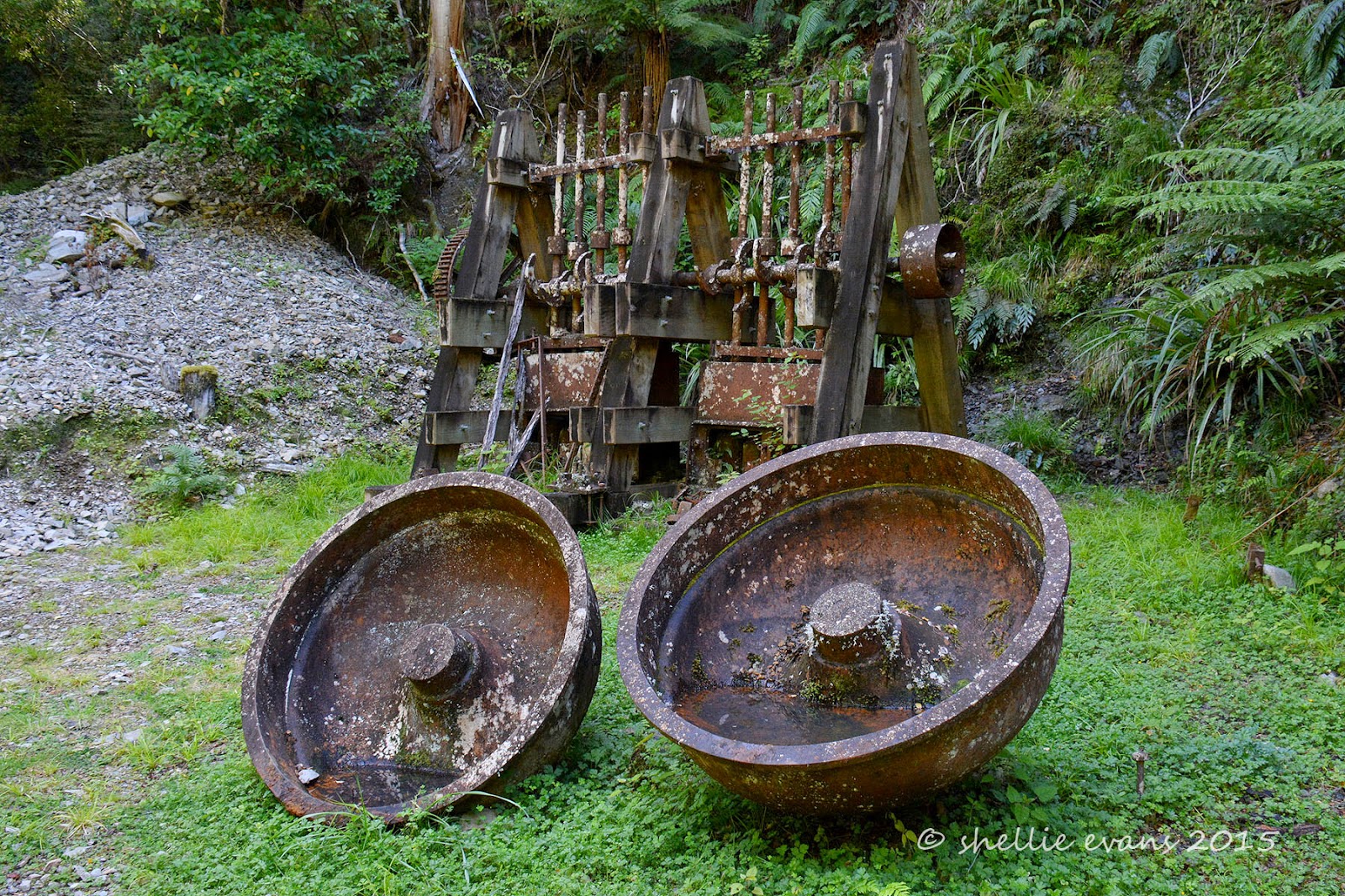
At the end of my walk are the remains of the Croesus Battery including two berdan dishes, which revolved to crush the gold bearing quartz using heavy steel balls, and various other rusting relics from the gold mining days.

I took the above photo from a platform where there are information panels about the site and also a sign suggesting people not venture down to the remains. (Click on the photo to enlarge to read)


I decided I wasn’t going to walk 2kms to see the battery and not get up close and personal with it. Many others must have thought the same, there was a well worn track down to the creek bed.

After having a scout round I climbed back out of the creek bed and returned back along the same track. Half way along, a well worn track dropped down to the creek again, There weren't any signs saying where it led to but I was hoping it was going to be to the cemetery. I had a map but not my reading glasses and the tracks on the map were so tiny I couldn’t see where it ended up.
Problem solved! I zoomed in with my camera, taking a shot and then blowing that up on the LCD screen. It would seem that I should have walked the track in the reverse direction, hence the reason there was no sign pointing to the cemetery. Although I think they still should have had one for directionally challenged people like me.......although I wouldn't actually say I'm directionally challenged. In fact I'm actually pretty good- I'm my father's daughter afterall, there's no denying that. It's more about not following the norm, I'm like a bull at a gate sometimes. I should have walked up to the top level and read the sign and map board up there instead of the biking and hiking 'Ghost Road' board on our level.

After a tough climb up the other side (another reason the walk started from the other direction) I finally came to the picturesque Lyell cemetery tucked into the bush.

Clinging to the hillside are a few surviving grave sites & headstones, in iron-fenced plots….

….with large trees growing out of some of them and in one case a fallen tree crushing the iron fence and knocking the headstone aside.

The headstones tell stories of short lives and tragic deaths, between 30 & 40 people were buried here from 1880 to 1900.

I pity the poor people who had to cart the newly departed to the graveyard, it was a fair hike along another ridge back to where the town (camp) was located.

Along the way was this gorgeous emerald green moss and fern covered rock face with a tiny little trickle of a waterfall, water seeped through elsewhere keeping the mosses moist and vibrant.

By the time I got back to camp, quite a few people had arrived in their sleeper vans & tents and had set up around the perimetre of the campground, all trying to find a level site and most spending time flapping their arms about trying to dispatch the sandflies. We are so lucky to have our insect screens and good bug spray (Bushmans).
These weka can't count!

The next day we were back on the road heading for Westport, I was looking forward to driving through the beautiful Lower Buller Gorge and seeing the 'famous in New Zealand' prominent landmark of Hawks Crag for the first time.


…then turned around and came back to pick me up, giving me ample opportunity of taking some great shots of the rig.

There is actually quite a bit of room above the vehicles but it sure doesn’t look like it when you’re in the cab.

He was chased back through by a petrol tanker who caught him up as he was doing a slow drive past for my benefit!

And here’s the view from the front seat. From the lookout the wooden pole looks like it’s supporting the rock overhang when in fact its quite a distance away from it. I wonder what its there for.

You must have quite a zoom on your camera re the Hawks Crag photo's, It's also part of the full Buller marathon course...the Buller sandflys are small and nasty they came through our bus insect screens...please tell more about "Bushmans" ciao J
ReplyDeleteMy zoom is 300mm but I really need more for my bird photos, something like 600mm would be great...so is the $$$ :) Bushmans is an Aussie product available at Hunting & Fishing Stores, I'd give it a 90% success rate, some blighters still get through the layers. It's 40% deet which is quite high but what's a girl to do.
Delete