Showing posts with label hill. Show all posts

July 28, 2015

Out & About in Alex

Our next stop was a short 9kms down the road in Alexandra, where we parked up for two nights at Molyneux Park, a NZMCA POP. There’s a three night maximum stay and only eight vehicles at a time, are allowed to park over but we had the place to ourselves except for one vehicle who arrived late and left early on the last night. A little different to the last time we passed through Alexandra when we called into check the site out and it was full.

Molyneux Park contains Alex’s sports fields and buildings which are used for a range of sports from rugby, soccer, cricket to judo and squash, it also contains the aquatic centre, a skateboard bowl and an ice rink. David enjoyed having a spa, and swim in the heated pool, at the Aquatic centre. Other than Saturday morning the place was pretty quiet (a hint  for fellow campers- don't park near the skateboard bowl where kids now ride their bikes). On Saturday there was a steady stream of vehicles moving up and down the road delivering children to their Saturday morning sports, most seemed to be running late to get somewhere, hitting the speed humps with a good thump.

The park is also very handy to town with the supermarket just down the road. An ideal place to stop and do all the chores except for the lack of an easy access dump station in town. Try filling up with petrol (for generator), diesel (for heater & ute), water for house tank and dump the three house waste tanks on the forecourt of a busy Caltex service station on a Saturday morning. Dumping right beside the drive through carwash is very off-putting, both for us and the people waiting in their cars in the queue. And I can imagine Subway just behind the dumping vehicles gets a few unpleasant smells when the wind is blowing the wrong way!


Busloads of children arrived and departed from the ice rink during the day. An ice rink is another novelty for me, this is the first outdoor ice rink I have seen. I learnt to roller skate on a concrete rink, that’s all we had in Napier. The Marine Parade rink was my ‘hang-out’ place when I was a teen. How cool that the local children learn to ice skate and curl as part of their winter school curriculum, a skill they’ll have for life.

I love the penguin sledges which help them with their balance as they learn, I wonder if they have bigger versions for adults..... Don’t you love that little guy's helmet. And going by his skating skills I don't think he'll be keen to give the sledge away anytime soon. He knew what he was doing, racing fast everywhere and knocking a few kids off their feet along the way. His helmet matched his character for sure.


I’m not sure whether the rather large scary looking wooden sculpture near the front gate entices the little kids in, I saw a couple  giving him a wide berth. It was interesting watching the kids curl, those white ‘things’ are for balance instead of the brooms the big boys use. Check out the small child in the background on the bottom photo, hanging onto the wall for dear life- I think that’d be me if I tried to give it a go. Ice skating is a lot harder than roller skating.


Before we left Alexandra, I took a drive up to the lookout, that’s the Clutha River along the back and the Manuherikia River in the foreground, their junction is at the top left near the steel truss arch bridge over the Clutha. The town centre is on the point on the inside of the rivers.


It was late in the afternoon but I managed to take a few church photos- this is St Enochs Union Church built in 1877.


And I found ‘Shaky Bridge’, an historic suspension bridge built over the Manuherikia River. Before the bridge was built the only way across the river was by punt, the bridge was also used by wagons and horses however today the bridge is strictly for pedestrians only.


The bridge opened in 1879 at a cost of £974 and was later sold for £1 to two settlers living across the river. The bridge fell into a state of neglect but was eventually repaired, it was at this time the bridge was narrowed to foot traffic only.


And across the bridge I also found a great little cafe, aptly name Shaky Bridge Cafe which is part of the Shaky Bridge Vineyard next door. I bet this place is busy during the weekend and over the summer, there were many walkers, cyclists and runners crossing the bridge on their circuits even while I was there. We’ll have to stop there the next time we are in town.


How many astute readers noticed the clock on the hill in the photo, two above? This Alexandra icon has been hanging above the town since 1968 and lit up at night, it can be seen 5kms away. Here are the facts and figures-
  • Diameter: 11m
  • Minute Hand: 5.6m including the counterweight.
  • Hour Hand: 4m including the counterweight.
  • Weight: Each hand weighs approximately 270kg. The driving mechanism weighs approximately 760kg.
  • Mechanism: Reduction gearboxes powered by one 3/4 hp synchronous motor.
  • Lighting: 150 torch bulbs, powered by a reduction transformer.
  • Structure: Six vertical steel columns averaging 7.3m in length, supported on concrete foundations, fastened into the rock face with steel supports.
  • Location: On the Knobbies Range to the east of Alexandra.
  • Height Above Sea Level: 200m

And one last photo, of the historic Vallance Cottage which was built in the late 1880s and lived in until the 1970s when there was still no running water inside and only cold running water in the separate wash-house. I didn’t check, but apparently the back door step is almost level with the ground due to the lady of the house being a “fastidious housekeeper” who scrubbed it daily. This tiny two bedroom mudbrick cottage was the home of William & Jean Vallance and their nine children. Nine children!!


April 10, 2015

Crazy Paving & Box Canyon Caves- Oparara Basin

The caves carpark is 3km further up the road and the caves, only a short 5 min walk away. It’s part of the Honeycomb Hill cave system and the only part accessible to the public without having to take a guided tour. A torch is a must, otherwise you can’t see a thing once you’re past the opening (which actually might be a good thing if you don’t like spiders or wetas!)


This track has taken a beating from Cyclone Ita and once again we see how much destruction has taken place with huge mature trees uprooted along a small ridge above the track. The root plates are monsters, with a 4 or 5 metre diametre and we can see how easily they were ripped out of the ground. Most are very shallow rooted and have been ‘peeled’ off the rocky base they are growing on.

There would have been a huge amount of work to do to get the tracks back to working (walking) order and we know that there are still many back country tramping tracks closed because of windfall. I'm sure it would have been heart-breaking for DOC workers & volunteers to see the carnage around them and so much work ahead of them too.


The first cave is the Crazy Paving Cave, it has a wire fenced walkway and paving stones inside to protect the unusual formations on the floor.


Beneath the low overhangs on the side of the cave (and only visible with a torch) is the ‘crazing paving’ that the cave is named after. Crazing paving- they look more like large chocolate squares to me- has formed across the floor of the cave, it’s very old and very fragile and is thought to occur where deep fine sediment has dried out very slowly.


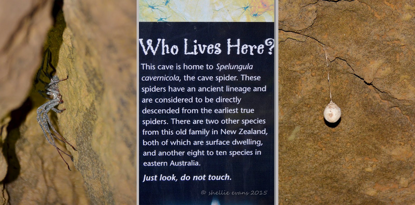
The cave is not very high, perhaps two metres or so and slowly decreases in height as you move into it. Shining the torch into the cracks and gaps in the ceiling not a few inches from our faces reveals the largest spiders you ever saw! Very special spiders, the information panel at the beginning tells us. Large egg sacks also hang from the ceiling.

Remember that it’s pitch black in here and I have to keep up with David whose keen to check out every nook and cranny for wetas & more spiders. Everytime he turns away I’m left in darkness, then he points the torch and there’s a spider or a  weta scurrying away right near my head. I am not happy. Thankfully the wetas are nowhere near as large or as numerous as the ones we found in a cave on the Coromandel.

As if I would!

We make our way to the next cave which is up a stairway to a the level above.


A wooden staircase leads down into the cave.


Box Canyon is one humongous cave, deep, tall, wide and dark. Very dark. From this angle you can also see how the cave got its name.


There are a number of side passages and David’s off exploring again. He squeezes through a passage opening and disappears around a corner. I’m left in darkness and I’m not impressed. Considering David’s aversion to small spaces, I’m surprised he’s so keen to check out the back recesses of the cave.


I take a photo looking back towards the entrance before we round a corner and move further on into the cave looking for glow-worms. There are no wetas or spiders back this far, they tend to like living around the entrance where there’s a bit of light and moisture to attract their prey. Once we’re around the corner we turn off the torch to check the ceiling for glow-worms.

It’s pitch black, not an ounce of light anywhere, you can’t see your hand in front of your face but as our eyes adjust and we look up at the ceiling we see a sprinkle of tiny pin-head sized lights spread across like a miniature Milky Way. Glow-worms! It’s always a delight to come across these tiny treasures when we explore. One day I’ll make the time to set up my camera & tripod to capture them in their natural state. If we turn the torch on them they switch off their lights so it'll need to be a long exposure in the darkness.


It’s too dark for me at the back so I stumble back towards the entrance, checking the sides for anything interesting. I find a tide line, at about my head height, on the stalactites that hang down from the top of the cave. I can’t say that’s very reassuring. It would be some huge downpour to fill this cave, imagine that, one monster swimming pool. At least there's a ladder to help you get out.


We climb back out of the cave, very impressed with what we’ve seen and this is only a small portion of what has been found and explored in the Honeycomb Hill cave system.


April 09, 2015

Lost World- The Oparara Basin

Ten kilometres north of Karamea is the turnoff to the Oparara Basin, a hidden valley 14kms up another narrow, rough gravel road (an old forestry road) and inside the Kahurangi National Park. Yet again we are visiting Kahurangi, the largest National Park in New Zealand and one we have visited many times on our journey around the top of South Island.


I’ve said it before and I’ll say it again, the distance travelled on a gravel road always feels at least twice as long as it actually is, probably because of the slow speed (it took us 45 minutes) and the bumping about inside the cab. This road was no different. It started out well but steadily got worse with many corrugations and washouts and a few steep sections where there was no gravel or dirt, just bare rock where the road had been cut through.

All the same it was a lovely drive with thick rainforest bordering & sometimes forming a tunnel over the road with occasional glimpses of a rocky creek bed down below the road. Splashes of red from the flowering rata vines grabbed your attention here and there. It’s been a good summer for the rata, they are still flowering long after there usual season. Possum control must have also helped.


It was a great surprise, after not seeing another person or vehicle on the way in, to finally arrive at the end of the road and find this information shelter and a quite a few cars. What a lovely welcome to the Oparara Basin this is; toilets, shelter, interpretation panels and picnic tables.


The Oparara Basin has been called the ‘lost world’ and is one of the finest features of the Kahurangi National Park. Along its course through the basin, and over 35 million years, the Oparara River has carved out three massive limestone arches and numerous cave systems.

At the end of the road and just a few kilometres further on from the public carpark is the highly fragile Honeycomb Hill cave system; a 13km maze of tunnels with over 70 entrances & only first explored in 1980. This cave system contains the remains of over 50 species, including the extinct moa and New Zealand eagle and is only accessible by guided tour to protect the fragile and unique environment. Within this protected area is the Honeycomb Hill Arch, the basin’s third and remotest arch.

There are two arches we are allowed to visit & we decide to visit the Oparara Arch first, the largest natural rock arch in the Southern Hemisphere. The 1km walking track follows the Oparara River upstream. We keep an eye out for Blue Ducks/Whio, there’s a breeding population located in the basin but once again we miss out on seeing them.


The walkway is well formed and very picturesque with ferns and moss growing everywhere and over everything. David sets his track timer going and we’re off….


We pause at the edge of the river where it’s very still and reflective. The dark tannin stained water turns a rich gold colour as it flows over the shallow edge. Cup of tea anyone?


Thick moss and lichen encrusted branches overhang the river and the track like ghostly arms and David is sure James Cameron’s inspiration for the movie Avatar must have come from here- or in fact Weta Workshops inspiration. He feels like he’s walking through a movie set and large blue people will spring out at him at any moment.


And here’s our first glimpse of the huge arch, a land bridge over the top of the river.


And directly underneath, looking up.


The track leads us up into a huge cavern where there’s an old sign with the measurements. Apparently these are not quite right though- DOC’s measurements put the arch at 219m long, up to 79m wide, and 43m high.


We make our way down to the river bed….


Where we can now see the other end of the tunnel….


We wade through the river, (wearing our Tevas was a good idea- most people had walking shoes or tramping boots on), crossing it a couple of times before reaching the other end.


The water is cold but not too deep….


Until the last crossing where it’s quite swift and there’s a deep pool. The rocks are also slippery so we decide we’ll not risk getting wet. A pity because I’m sure there would have been some blue ducks up further! The boulders and rapids we can see  around the corner look like ideal blue duck territory.


We head back towards the entrance…


And I take a photo of David standing below the impressive arch.


Back along the track I stop to take some close ups of the rich green mosses and the stunning moss covered rocks that surround a stream which flows down into the river.


And stop by the river again where I spot these rocks with their contorted faces & hair tuffs.


Back at the carpark we see that our foreign neighbours(with their very young daughter) from the Karamea Domain Campground have parked beside us. In their hire motorhome. Hmm....they obviously can’t read and we’re not sure how on earth they managed to manoeuvre their van over the road without doing some serious damage.


And I can’t imagine what they would have done had they met anybody coming from the opposite direction. The width of the road would have been little more than the van itself and there were very few areas to pass or pull over should another vehicle approach. But there you go, they made it there and back, and were tucked up safe and sound on their site by the time we returned. We heard that the grader was due through the road the next day, I wonder what would have happened had anyone met that on the road let alone a large campervan.

Still to come from the Oparara Basin-

Crazy Paving  & Box Canyon Caves
Mirror Tarn
Moria Gate


February 26, 2015

Sawcut Gorge: Part 2

After wading through water, crossing the Waima River at least 30 times, clambering over rocks and boulders in the river bed for the last hour and a three quarters, we took a short steep bush track up and over and into Isolation Creek where the Sawcut Gorge is located. For another 5 minutes or so we scrambled over more boulders before finally turning a corner to find the Sawcut Gorge right in front of us looking very narrow and like a deep cut in the rock wall. Duh- hence the name Sawcut.


Sawcut Gorge is New Zealand’s finest slot canyon and comparable to the slot canyons of Utah in States. The chasm is 50m deep, 50m high and in places only 2m wide.

It’s not until you see a person near the entrance that you get an idea of how impressive the canyon is.


The “Sawcut” itself is a short and narrow passage where Isolation Creek has eroded through a 50m high wall of limestone, leaving a unique slot that’s higher than it is long.

Inside the canyon the water is cool and clear and free of algae (it needs sun to grow), we wade through marveling at the smooth, curved and colourful walls….


.....and the plants that are hanging off the sides in places. David stops to talk to three women coming back through the canyon…..


And I wait until they pass so I can catch their silhouette against the opening & before they exit ….


They also stop to take photos of each other and then they are gone…


David carries on and by the time I catch him up he has settled on a rock waiting to have lunch. The ‘party’ we had been told about were also having their lunch on the rocks just outside the canyon. With little space, we had to walk right through the middle of them to get past….


As did these girls that came through while we were resting. I’m sure they were on a ‘hen party’ weekend, they were carrying water pistols & bow & arrows, some had cowboy hats on and others Indian feathers in their hair bands. They were headed for Isolation Hut, a 6 bunk DOC hut an hour further on up Isolation Creek, I hope there are none others up there otherwise they’re going to be sharing a bunk or two. I walked up the creek after them for another couple hundred metres or so to see if the boulders got any smaller. They didn’t.


After a short rest and a bite to eat, David went ahead of me back through the slot so I could get a silhouette shot of him as we passed through. Two guys were approaching from the other end, both wearing gumboots (wellington boots). Well they had been wearing gumboots, they were holding them and wading through the water, fancy coming all this way wearing gumboots! No grip whatsoever, they must have struggled walking over all those rocks in the riverbed and have sore feet when they did have to remove the boots.

One of the guys had a gun slung over his shoulder, they told David they were heading for the hut where they were going to go hunting for deer. Ah-oh, 2 + 5 + any others = too many people, not enough bunks.


I waited for the guys to pass me before heading out, David was patiently waiting for me. Well actually he was waiting and checking, yet again, his tracking app on his phone- David will never be lost in the bush!


We headed off down the creek, back over the bush track, around the corner and back into the Waima River bed.


The return trip is just as confusing and just as demanding. Nothing looks familiar. Except DOC’s orange triangles pointing the likely way to go.


The stark white limestone boulders are very impressive, they look like blocks of ice at the end of a glacier.


We come across two groups of people making their way to the gorge, the guy on the right is filling his water bottle, the group at the back are having a water fight, cooling down on a hot afternoon. They still have around a 40 minute walk to get to the gorge and it about 3pm. Unless they hurry up they’re going to be walking back down a cold riverbed. The sun is due to disappear behind the bluffs above us.


Back behind us another two groups are making their way back to the carpark. The front group told us, when we saw them later at the cars, that they stopped to have a swim in a large pool- the one we had waded through on the way up. The one with the ‘pet’ eel. They didn’t mention an eel encounter so perhaps he has hibernated through the hot summer.


Part of the track passes through the bush on the side of the river, it’s narrow and steep and requires a bit of maneuvering around and holding onto tree trunks.


It is with some surprise we come up behind a family group gingerly picking their way over the rocks. A couple with older parents, a toddler in the backpack and a 3 year old, holding his own over the rocks. They proudly tell us they’ve been to the Gorge and their son has walked the whole way. We haven’t the heart to tell them that they would have only made it to the reserve where the boulders are big and the bluffs are vertical above the river. It probably looked like a ‘Sawcut’ gorge.


The boulders make way for rocks and the walking becomes easier. We look back up the river and say a farewell to Isolation Hill.


Just a handful of crossings and near level ground ahead of us and we’re back at the car. I wonder if the slips that we see happened in the ‘quakes. And I wonder how long it took for them to be cleared.


Finally four and a half hours after setting off we were back at the ute. We sat on the tailgate in the hot afternoon sun with a welcome cup of tea in hand, reflecting on the walk. With sore feet and stiff legs from all the rock hopping (and for me, a sore arm from carrying my camera the whole way) we decided that while it wasn’t exactly a gut-busting walk, it was very challenging.

You definitely need a walking pole to steady yourself climbing up and down the rocks and to check position & stability of them in the water, and the water depth in some of the deeper pools. A sign at the homestead, by the visitors book, made me smile- ‘Please leave your walking sticks in the river bed where they belong’. It was just as well I didn't get a bunch of flowers for our anniversary the other week, I got a lovely new walking pole from David! I had my hands full; pole in one hand, camera in the other plus sunglasses on my head and pack on my back, it was all a bit of a juggling act!

We also found our Teva enclosed sandals ideal for grip on the rocks and for the river crossings; the gravel only occasionally getting caught under our feet but easy to flush out with the river flow while still walking. And make sure you wear sunglasses on a bright day, the glare off the white rocks is brilliant.

I would highly recommend this walk if you are a reasonably fit and active person (who doesn't have a gammy leg or knee) but personally I wouldn’t like to do it any earlier that mid to late summer; the water level would not only be higher it would also be very cold before then.

And you’d miss out on seeing the 'Naked Ladies'.