Showing posts with label otira. Show all posts

Thursday, May 28

Otira Valley, Arthurs Pass

One walk we were keen to do while in Arthurs Pass was up the Otira Valley, it’s here, high up towards the head of valley that a very small population  of very rare Rock Wren live (no more than 6-10 birds). Rock Wrens, as their name suggests, live in rocky and craggy areas high above the mountain bush line, they are New Zealand’s only true alpine bird never moving from their boulder home (Kea, our alpine parrot, move in and out of the bush).

You might remember, we’ve searched for Rock Wrens (Maori name Piwauwau) before, while in Fiordland at the Boulder Garden beside the Homer Tunnel, and at the head of Gertrude Valley, finding no birds in either location. We were going to be out of luck in the Otira Valley too.

The relatively easy track, leaves from a car-park beside the road, just east of Arthur’s Pass summit.


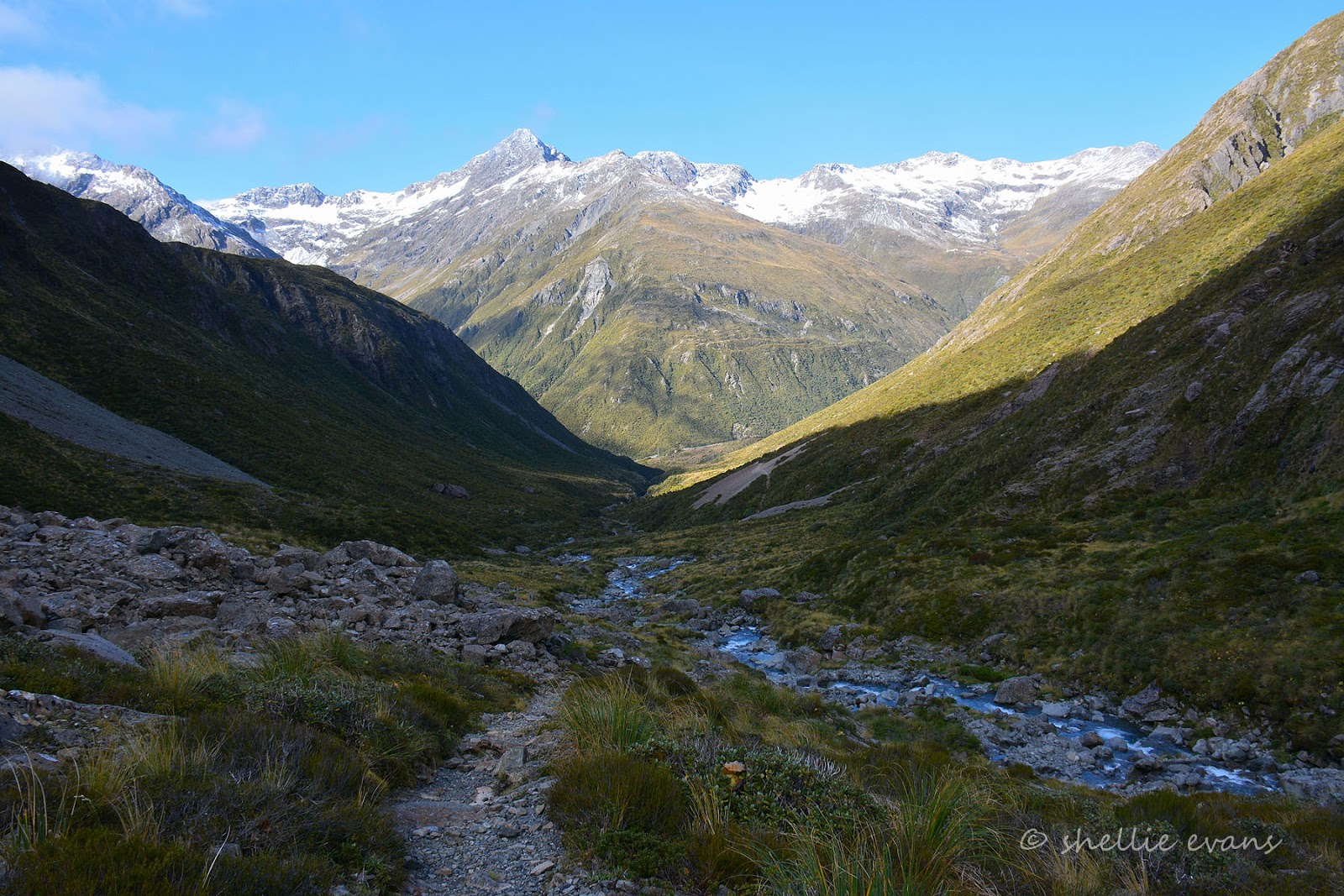
The track heads up a deep alpine valley on the northern side of Mt Rolleston climbing over an old glacial moraine (dirt & rock that has been formed or pushed along by glaciers as they move), and passing through subalpine scrub and tussock all the way to the Otira River foot-bridge. It’s not recommended walking the track during winter due to the avalanche risk higher up the valley and I guess there'll be plenty of snow up there now after the polar blast the country experienced a few days ago.


Looking back towards the carpark & road, we can see the Otira River which we've been following up the valley, once it reaches the road it turns west and heads down under the Otira Viaduct just around the corner.


It’s a steady and rocky climb up the valley, solid tramping boots with ankle support,and a walking pole are a major benefit when crossing some of the rocky streams that cascade down the mountainside and weave their way between boulders and rocks on their way to join the Otira River. We catch up to three fellow hikers who let us pass just before we cross Otira Slide a rather large rock slide that is part of the moraine.


It’s hard to give scale in the photos when there are no people but this one shows the angle of the track across the mountain side. We were lucky that DOC had recently cleared the summer growth from the track and it’s margins, it made it easier to walk.


Finally ahead of us we can see our target, the footbridge across the river. The Rock Wrens live in the area from just above the bridge to higher up towards the snow line at the top of the valley (or the Otira Face) which is about another hours walk further on.


I wait at the bridge for David to catch up, this last section before the bridge is very boggy and rocky with water seeping through to the river from all directions.


The bridge is bolted to the rocks and is most likely removed during winter due to the risk of an avalanche sweeping it away.


An unmarked route continues on from the footbridge and climbs rock scree and boulders to the head of the valley. This is recommended for experienced trampers only, there are a series of lightly marked poles and rock cairns to follow although for us there’s a well worn track after what has obviously been a busy summer.


We climb a little higher and find a suitable spot to have our lunch and rest behind a large boulder out of the cold wind. We can see, looking back down the valley, the three walkers we passed crossing the rock slide.


If you look up behind the walkers to the mountain across the highway you can see a few buildings. This is the Temple Basin skifield, a club skifield on Mt Temple, below are zoomed in photos of the buildings. Skiers access the skifield via a steep 45 minute walk from the highway. Most of the skiable areas are also accessed by hiking between the 3 rope tows.


I decide to carry on up the valley, leaving David to scan for the wrens in the rock gardens above the bridge. I have my notes from the bird forum and some members have found the wrens at least an hour further on. I’ll walk for another 30 minutes or so before turning around and taking my time coming back down. Stopping, watching and waiting every few metres. After crossing a large rocky scree, the route becomes more involved, climbing over and around the jumble of boulders as it tracks close to the river. On it's way down the valley, the river forms many deep cold blue pools and small rocky waterfalls.


Looking back down the valley, the footbridge is about centre, just below the sunny rock slide on the right (that’s the large one we crossed on our way up). You can see the path I’ve taken on the left as it crosses the scree.


It was here as I was admiring the scenery that I heard the faint but familiar ‘keeaa’ coming down the valley. It took me a while to spot the source of the noise, they really are just tiny dots in a vast landscape when flying. Four kea (mountain parrot) were flying high above me following the contours of the mountain side down towards the road.

I was surprised to see two of them land on a rock across the river from where I was. This was the juvenile and parent I mentioned in the previous post, the baby was begging and calling. Perhaps they had to stop here for a rest before continuing on. I didn’t see them leave, as I moved further on up but I did see (and hear) another bird approaching and managed to get a long distance shot of the beautiful colours under his wings.


I climb around a corner and above a larger waterfall to find I have the mountain to myself; no road, no power pylons. no wires & no people. The silence is deafening and the views around me are just spectacular.


I walk a little further on and find a place to sit and soak it all up (and scan for Rock Wren). Above me is the head of Otira Valley and even though it looks close it’s probably another 30 minutes climb to the snow line. Across the river,  a ribbon of water falls from high up Mt Rolleston. There’s a marker pole ahead of me and I decide that’s as far as I’ll climb. The sun is fast disappearing out of the valley floor and the air is cool and crisp.


I head back down, stopping every 20 metres or so to sit quietly on a rock carefully watching for any movement. I scan all the likely places the wren might be hiding, willing them to make an appearance. But nothing, it looks like the wren will remain on our ‘to see’ list. It’s not long before I catch sight of David, he’s climbed up the rocky wall behind the bridge and has found a boulder to stand on as he scans for the elusive little bird, he has no luck either.


In summer the valley, from here at about 1400 metres down to the carpark, would be full of flowering alpine plants including the Mt Cook Lily and Mountain Daisy. And perhaps the wren might be more obliging in the warmer weather.

I meet David back at the bridge, it’s now quite cold with the sun gone and the wind whistling down the valley so we make haste along the track and back to the ute.


A pity we didn’t find the wren once again but still, a great walk and spectacular scenery made up for some of the disappointment. Those elusive Rock Wren don’t have us beat just yet, we have the luxury of having time up our sleeve, we’ll be back this way again some time in the future.


Saturday, May 23

Arthurs Pass- Heart of the Southern Alps

We had a fabulous time at Lake Brunner and were lucky to have a couple of fine days before the rain set in once again. We left Lake Brunner during a break in the rain, heading for Jacksons where we were going to wait until the weather cleared before crossing Arthurs Pass. You'll remember this post from earlier, well now I can tell you more about our drive over the Pass.

Arthurs Pass is one of three passes that link the east and west coasts of the South Island. The Pass climbs to more than 900 metres through Arthurs Pass National Park and is the highest and most spectacular pass across the Southern Alps.

It took three days before we awoke to blue sky and a view out over the Taramakau River valley.


Perhaps we should have stayed another day, the Jacksons Retreat Holiday Park had a number of walks, a waterfall, two lovely tumbling streams (which were gushing torrents by the time we left), lots of birds and glow-worms. But we were keen to cross the Pass while it was such a lovely day. On our way out we stopped at probably the prettiest dump station we’ve visited on our travels. The only problem being that the van was facing downhill and the tanks didn’t empty fully. But then that happens at other sites too, you’d be surprised how many aren’t level.


Just up the road is the historic Jacksons Hotel. The first Jacksons Hotel was built in 1868 and served as a stage coach post. It was rebuilt in 1872 on a higher site after it was washed away by the Taramakau River. The second building went up in smoke & was replaced by this one in 1910.


Our next stop is at the settlement of Otira which was once a bustling village of 600 people but now has a population of just ten or so people. The Otira Hotel was built in the 1860s and was also a stage coach post. After the Otira tunnel opened in 1923 the village became a busy railway settlement.


In 1998 Otira became famous in NZ when the whole township was sold for $73,000. The sale included the hotel, hall, fire station and 14 rentable houses on 20 hectares of leasehold land. Last year, after 4 years on the market, the pub was sold to a Motueka man.who plans to buy the rest of the settlement in a few years.

Although we didn’t meet the latest owner (he was away on a break) I get the distinct impression that he is slightly eccentric. As you can see, both inside and outside the pub, there is an eclectic collection of hundreds of items from a by-gone era. There doesn’t seem to be rhyme nor reason for some of the items, perhaps generous people have passed on their collections. I know I wouldn’t like to be the one dusting in there.


I got a bit of a fright when I opened one of the lounge room doors to see an old lady sitting across the room (left middle photo above). She didn’t have me fooled for too long though, I’ve seen the likes of her before. Paper mache ‘old people’ were regular visitors to Mum’s craft shop in Hawkes Bay. A lovely lady in Matata in the Bay of Plenty used to make them to sell and they’d sit in deck chairs outside the shop welcoming shoppers in- oh look, I just happened to have a couple of 'old people' photos! That's Mum in the centre on the right, in case you are thinking 'that one looks very realistic'- the photo appeared in the local paper.


Our next stop was at the Death’s Corner Lookout which overlooks the engineering masterpiece that is the Otira Viaduct. Opened in 1999, the 440 metre four span viaduct carries the road over a stretch of unstable land and replaced a narrow winding, dangerous section of the road that was prone to avalanches, slips and closures. As magnificent as the viaduct is I was more impressed with the artificial waterfall that was created to divert water over the two lane highway, to plummet hundreds of metres into the Otira River below.


One final stop at the summit of the Pass to check out the memorial to Arthur Dudley Dobson, pioneer, explorer, surveyor and civil engineer who discovered the pass in 1864 (although Maori did use it earlier). Arthur Dobson was born in London in 1841 and died in Christchuch in 1934 at the ripe old age of 93 - the fresh air obviously agreed with him.


We stopped in Arthurs Pass Village for a late lunch and then decided we’d stay in the village for a couple of days instead of heading further east to one of the numerous DOC camps along the way.


This DOC campground was a little different than most, it was just across the road from the DOC headquarters for Arthurs Pass National Park, just along the way from the railway station and backing onto the railway line and sidings including a historic turntable. The bank I’m standing on taking the photo is a flood bank for Avalanche Creek which runs through the centre of the village.


Avalanche Creek arrives in the village via three vertical waterfalls that cascade down the mountainside across the road from the camp. This small section is the waterfall at the bottom of the falls, the middle section can be viewed from a platform just above these and there’s a very steep track up to the top section. The water, as you can see is crystal clear, it pools just over the bank from our camp and disappears into the gravel underneath the rail bridge before emerging into the Bealey River on the other side. The gravel must be very porous because it’s hard to imagine that amount of water not forcing the flow all the way to the river.


The middle waterfall forms a beautiful backdrop to Arthurs Pass Chapel’s main window. Like a number of churches around the country nature does a great job at providing a moving living stained glass window.


Arthurs Pass Village began its life as a road construction camp and then grew to provide services for travellers on the road providing, amongst other things, fresh horses for the weary travellers on the 2-3 day journey. Between 1907 and 1923 the village became a worker’s camp during the construction of the Otira railway tunnel. Many of the holiday cottages tucked into the bush around the village are former worker’s huts. The post office was one of the more unusual post offices we’ve seen on our travels. It looked more like a bus shelter and I bet it would be very cold collecting your mail in the middle of winter!


There are numerous walks around the village and along the Pass but other than a short walk to Bealey Chasm we didn’t do any of the popular walks.  We did spend an afternoon hiking up the Otira Valley in search of the elusive Rock Wren- I’ll do a separate post on that- but with the sun not reaching into the valley until late morning and it being bitterly cold outside until then, we stayed in the van tucked up in the warmth.

Historic Jacks Hut, a restored roadman’s cottage, sits across the road from the Chasm carpark.


Some of the most prominent features of the village are the railway yards, buildings and railway stations (old & new). Not so visible is the entry to the 8.5km long Otira tunnel, in part because it’s hidden in the shade all day long. The entrance is the dark hole at the end of the bridge in the top left photo.

And while the Arthurs Pass is mostly a peaceful alpine environment, there is the frequent rumble of passing trains, day and night.


Most of the trains were hauling coal wagons back and forth from the West Coast coal mines, it was interesting to note that 5 engines were needed to pull the wagons up to Arthurs Pass from Greymouth. And only two were required to take the empty wagons back to the Coast; on occasion the 3 spare engines were hooked onto the back of the passenger train.

Twice a day the Trans Alpine Passenger Train pulled into the station, the train transports visitors on, what some say, is one of the worlds great train rides through some stunning scenery. Personally I think the road journey is more spectacular- we have done the train, 17 years ago, but I have little recall of it other than the tunnel which went on and on. Odd when it’s the scenery that I should have remembered. Although I do remember stopping at the old A frame railway station and hoping for a kea to make an appearance (they didn’t). The old station has now been replaced with a long low profile concrete and stone building- you can see it in the background of the photo of our van back near the top of the post.


Near the underpass to the station is this information board with the rock and the carved logo beside it. It’s a pity that lichen is overtaking the emblem.


Still to come from Arthurs Pass-

Cheeky, Curious & Charismatic Kea
Stunning Otira Valley