April 10, 2015

Crazy Paving & Box Canyon Caves- Oparara Basin

The caves carpark is 3km further up the road and the caves, only a short 5 min walk away. It’s part of the Honeycomb Hill cave system and the only part accessible to the public without having to take a guided tour. A torch is a must, otherwise you can’t see a thing once you’re past the opening (which actually might be a good thing if you don’t like spiders or wetas!)


This track has taken a beating from Cyclone Ita and once again we see how much destruction has taken place with huge mature trees uprooted along a small ridge above the track. The root plates are monsters, with a 4 or 5 metre diametre and we can see how easily they were ripped out of the ground. Most are very shallow rooted and have been ‘peeled’ off the rocky base they are growing on.

There would have been a huge amount of work to do to get the tracks back to working (walking) order and we know that there are still many back country tramping tracks closed because of windfall. I'm sure it would have been heart-breaking for DOC workers & volunteers to see the carnage around them and so much work ahead of them too.


The first cave is the Crazy Paving Cave, it has a wire fenced walkway and paving stones inside to protect the unusual formations on the floor.


Beneath the low overhangs on the side of the cave (and only visible with a torch) is the ‘crazing paving’ that the cave is named after. Crazing paving- they look more like large chocolate squares to me- has formed across the floor of the cave, it’s very old and very fragile and is thought to occur where deep fine sediment has dried out very slowly.


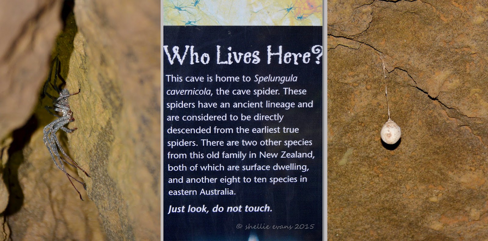
The cave is not very high, perhaps two metres or so and slowly decreases in height as you move into it. Shining the torch into the cracks and gaps in the ceiling not a few inches from our faces reveals the largest spiders you ever saw! Very special spiders, the information panel at the beginning tells us. Large egg sacks also hang from the ceiling.

Remember that it’s pitch black in here and I have to keep up with David whose keen to check out every nook and cranny for wetas & more spiders. Everytime he turns away I’m left in darkness, then he points the torch and there’s a spider or a  weta scurrying away right near my head. I am not happy. Thankfully the wetas are nowhere near as large or as numerous as the ones we found in a cave on the Coromandel.

As if I would!

We make our way to the next cave which is up a stairway to a the level above.


A wooden staircase leads down into the cave.


Box Canyon is one humongous cave, deep, tall, wide and dark. Very dark. From this angle you can also see how the cave got its name.


There are a number of side passages and David’s off exploring again. He squeezes through a passage opening and disappears around a corner. I’m left in darkness and I’m not impressed. Considering David’s aversion to small spaces, I’m surprised he’s so keen to check out the back recesses of the cave.


I take a photo looking back towards the entrance before we round a corner and move further on into the cave looking for glow-worms. There are no wetas or spiders back this far, they tend to like living around the entrance where there’s a bit of light and moisture to attract their prey. Once we’re around the corner we turn off the torch to check the ceiling for glow-worms.

It’s pitch black, not an ounce of light anywhere, you can’t see your hand in front of your face but as our eyes adjust and we look up at the ceiling we see a sprinkle of tiny pin-head sized lights spread across like a miniature Milky Way. Glow-worms! It’s always a delight to come across these tiny treasures when we explore. One day I’ll make the time to set up my camera & tripod to capture them in their natural state. If we turn the torch on them they switch off their lights so it'll need to be a long exposure in the darkness.


It’s too dark for me at the back so I stumble back towards the entrance, checking the sides for anything interesting. I find a tide line, at about my head height, on the stalactites that hang down from the top of the cave. I can’t say that’s very reassuring. It would be some huge downpour to fill this cave, imagine that, one monster swimming pool. At least there's a ladder to help you get out.


We climb back out of the cave, very impressed with what we’ve seen and this is only a small portion of what has been found and explored in the Honeycomb Hill cave system.


April 09, 2015

Lost World- The Oparara Basin

Ten kilometres north of Karamea is the turnoff to the Oparara Basin, a hidden valley 14kms up another narrow, rough gravel road (an old forestry road) and inside the Kahurangi National Park. Yet again we are visiting Kahurangi, the largest National Park in New Zealand and one we have visited many times on our journey around the top of South Island.


I’ve said it before and I’ll say it again, the distance travelled on a gravel road always feels at least twice as long as it actually is, probably because of the slow speed (it took us 45 minutes) and the bumping about inside the cab. This road was no different. It started out well but steadily got worse with many corrugations and washouts and a few steep sections where there was no gravel or dirt, just bare rock where the road had been cut through.

All the same it was a lovely drive with thick rainforest bordering & sometimes forming a tunnel over the road with occasional glimpses of a rocky creek bed down below the road. Splashes of red from the flowering rata vines grabbed your attention here and there. It’s been a good summer for the rata, they are still flowering long after there usual season. Possum control must have also helped.


It was a great surprise, after not seeing another person or vehicle on the way in, to finally arrive at the end of the road and find this information shelter and a quite a few cars. What a lovely welcome to the Oparara Basin this is; toilets, shelter, interpretation panels and picnic tables.


The Oparara Basin has been called the ‘lost world’ and is one of the finest features of the Kahurangi National Park. Along its course through the basin, and over 35 million years, the Oparara River has carved out three massive limestone arches and numerous cave systems.

At the end of the road and just a few kilometres further on from the public carpark is the highly fragile Honeycomb Hill cave system; a 13km maze of tunnels with over 70 entrances & only first explored in 1980. This cave system contains the remains of over 50 species, including the extinct moa and New Zealand eagle and is only accessible by guided tour to protect the fragile and unique environment. Within this protected area is the Honeycomb Hill Arch, the basin’s third and remotest arch.

There are two arches we are allowed to visit & we decide to visit the Oparara Arch first, the largest natural rock arch in the Southern Hemisphere. The 1km walking track follows the Oparara River upstream. We keep an eye out for Blue Ducks/Whio, there’s a breeding population located in the basin but once again we miss out on seeing them.


The walkway is well formed and very picturesque with ferns and moss growing everywhere and over everything. David sets his track timer going and we’re off….


We pause at the edge of the river where it’s very still and reflective. The dark tannin stained water turns a rich gold colour as it flows over the shallow edge. Cup of tea anyone?


Thick moss and lichen encrusted branches overhang the river and the track like ghostly arms and David is sure James Cameron’s inspiration for the movie Avatar must have come from here- or in fact Weta Workshops inspiration. He feels like he’s walking through a movie set and large blue people will spring out at him at any moment.


And here’s our first glimpse of the huge arch, a land bridge over the top of the river.


And directly underneath, looking up.


The track leads us up into a huge cavern where there’s an old sign with the measurements. Apparently these are not quite right though- DOC’s measurements put the arch at 219m long, up to 79m wide, and 43m high.


We make our way down to the river bed….


Where we can now see the other end of the tunnel….


We wade through the river, (wearing our Tevas was a good idea- most people had walking shoes or tramping boots on), crossing it a couple of times before reaching the other end.


The water is cold but not too deep….


Until the last crossing where it’s quite swift and there’s a deep pool. The rocks are also slippery so we decide we’ll not risk getting wet. A pity because I’m sure there would have been some blue ducks up further! The boulders and rapids we can see  around the corner look like ideal blue duck territory.


We head back towards the entrance…


And I take a photo of David standing below the impressive arch.


Back along the track I stop to take some close ups of the rich green mosses and the stunning moss covered rocks that surround a stream which flows down into the river.


And stop by the river again where I spot these rocks with their contorted faces & hair tuffs.


Back at the carpark we see that our foreign neighbours(with their very young daughter) from the Karamea Domain Campground have parked beside us. In their hire motorhome. Hmm....they obviously can’t read and we’re not sure how on earth they managed to manoeuvre their van over the road without doing some serious damage.


And I can’t imagine what they would have done had they met anybody coming from the opposite direction. The width of the road would have been little more than the van itself and there were very few areas to pass or pull over should another vehicle approach. But there you go, they made it there and back, and were tucked up safe and sound on their site by the time we returned. We heard that the grader was due through the road the next day, I wonder what would have happened had anyone met that on the road let alone a large campervan.

Still to come from the Oparara Basin-

Crazy Paving  & Box Canyon Caves
Mirror Tarn
Moria Gate


April 08, 2015

North- To The End Of The Road

Ok, back to it. Just so you don't get confused, these next few blog posts are from the last couple of weeks when we travelled from Westport up to Kohaihai and then returned heading south to Lake Kainere for Easter (& where we still are and still sitting it out in the pouring rain- I know the West Coast has something like 200 days of rain a year but this is ridiculous!)


We left Westport, heading north along the coast, bound eventually for the DOC camp at Kohaihai at the end of the road and where the Heaphy Track ‘Great Walk’ starts. It’s only a little over 100kms to the end of the road but, as has become our custom, we only move 40-50kms before setting up camp again. With no itinerary and all the time in the world to get there, we enjoy the luxury of not being in a hurry.

Our first stop is at the Gentle Annie Beach Campground which is just over the river from the tiny beach settlement of Mokihinui. The campground was on the corner of a working farm, a large grassy open area with smaller sites surrounded by hedges (no powered sites), and just across the road from the beach. The cafe come resident’s lounge was called the Cowshed Cafe and was in fact located in an old cowshed.


A 4km gravel road led down to the Gentle Annie Beach, leaving the main highway just over the Mokihinui River bridge and just before the long and winding climb over the Karamea Bluff. Later we took a drive over to Mokihinui where there was a collection of older houses and holiday baches. The Tavern looked like it may only be used over the summer holidays (and during whitebait season no doubt). The photo, middle right is looking back over the river mouth to our camping ground.


Across the road from the campground the beach was lined with diftwood in all directions. Great big piles of it snaked along the tide lines off into the distance. In some places the row curved far into the paddock where rough seas had carried it through gaps in the sand bank. West Coast’s iconic nikau palms grow randomly through the paddocks, spared by the settler’s axe many years ago, although providing little shade for the stock they are a visual treat. Hundreds more poke their heads out from the thick native bush behind.


Abandoned houses make interesting photo subjects….


We couldn’t believe our eyes one morning when a neighbour opened their door to let three large dogs out. It wasn’t a very big caravan, I don’t like to think what it was like inside especially when they all came running back from the beach covered in water and sand and went racing straight inside! I did feel rather sorry for them when they were tied up together though, one was a young dog who kept moving about and tangling the other two up or dragging them form side to side.


We did a couple of short walks while in the area (short being the operative word!) Not far inland, along side the river is the tiny farming settlement of Seddonville. Seddonville, you might remember, is where the 80km Ghost Road bike trail and tramping track finishes- it starts at Lyell, in the Buller Gorge where we stayed.

The Chasm Creek Walkway is a short 2km track that runs along the river bank & beside the road (obscured by bush) just before Seddonville. It was once a rail corridor for the line used to cart timber & coal from mills & mines further up the valley. We were a little worried whether we’d get to see the tunnel and the glow-worms on the walk as there was a notice saying the footbridge was closed.

We took a chance and while the first 500 metres- apart from the splashes of red from the flowering rata vines- was very non-descript, just a bit further on the most amazing and beautiful moss hanging gardens came into view. Growing on both sides of the rock cutting before the entrance to the tunnel and also overhanging the tunnel opening were many vibrant shades of green & rust coloured mosses which draped and smothered the surrounding rock faces, while behind a fine layer of water seeped down the walls keeping everything moist and spongy. A curtain of water also dripped down on us as we entered the tunnel. In some places the moss was at least a foot deep.


The tunnel was short and and the track finished at the bridge just on the otherside- we’d chosen the right end to walk from- you could also walk in from the road closer to Seddonville but this would have been frustrating, seeing the tunnel across the closed bridge and not being able to get there. The bridge had been boarded up and there was no way around it. It was obviously the old rail bridge over Chasm Creek and closed for safety reasons. It didn’t look like there were going to be repairs done to it any time soon, if at all. Which would be a shame as it a good little walk to do if you’re in the area.


After Chasm Creek we drove further on into the valley, past Seddonville and down a gravel winding road(what’s new?) for about 10kms. This brought us to the northern end of the Charming Creek Walkway which starts in Ngakawau 3hrs walk away and follows the corridor of, once again, an old railway. Just over the bridge from the carpark are more remnants from an old coal mine and timber mill. Charming Creek Walkway is rated as one of the South Island’s top five day walks but I can’t confirm whether this is true or not as we decided to give it a miss. Perhaps we’ll walk it the next time we’re in the area.


Our next stop heading north was Karamea but not before crossing over the Radiant Range on a 26km winding and sometimes narrow road that winds its way up and over the hills. Who would live in Karamea I wonder- not many I find out later- having to drive all this way to get to civilization and then its only Westport (sorry Trev). Karamea is about as far as one can get away from it all in New Zealand (by motor vehicle at least). A place of endless wild beaches fringed with nikau palms and feeling like a remote Pacific Island (when the sun is shining).

All through the hills great swathes of mature native trees lay fallen like pick-up-sticks in no particular order. Other trees have had their top halves ripped off. And right beside the dead and dying, corridors of trees are the living; standing tall and green, the lucky ones, spared from nature’s powerful fury. This is the aftermath of Cyclone Ita which roared across New Zealand during Easter 2014, hitting the West Coast especially hard. We’re going to see quite a bit of devastation and windfall on our travels.


We emerge from the hills at Little Wanganui and decide to have lunch at the Little Wanganui River mouth, freedom camping is allowed along the road to the mouth but from what we saw there aren’t too many spots to park up at other than right at the mouth itself where we found a fire still burning from the last overnighters. The sea is very rough and the incoming tide pushes the waves up the river threatening to snuff the log fire out with each surge. It must be a man thing- the hunter/gatherer gene, but David adds a few more pieces of wood to the fire.

This was one of our more interesting lunchtime views; straight out onto the rolling surf, we watched as the waves crept closer and closer to the burning log but left before it was wiped out.


Two surfers were looking for a ride and swum across the mouth and out into the white water dodging a flotilla of large bobbing logs and a raft of smaller driftwood along the way.


We stayed for a couple of nights at the Karamea Domain campground, a pleasant enough spot beside the Karamea River and across the playing fields from the school. There was a lawn bowling tournament on beside the drive into the Domain. They all stopped to gawp as we squeezed by.


Karamea is certainly small, I’m not too sure what I was expecting but it wasn’t one hotel, a small garage with fuel pumps, a police station, two churches, a Four Square supermarket, a couple of tour company businesses, half a dozen accommodation houses and many dairy farms. This is really the back of beyond and I take my hat off to the people who choose to live this far away from a reasonably sized city, it would definitely be a life-style choice in my opinion. Tourism and dairy farming looked to be the mainstays that keep people out here.

We passed the local cop taking the school students through their bike riding skills on the tennis court when we left the Domain.


We did a spot of bird watching while exploring the huge estuary that the Karamea River opens into, an estuary that was formed during the 1929 Murchison earthquake when the Karamea Port was blocked off.

An Australasian Harrier Hawk keeps a lookout for dinner along a feeder stream.


David spotted a White Heron/Kotuku flying over the Domain and we were lucky enough to spot it again when we went to check out Flagstaff Beach. It was feeding on the estuary edge and no amount of stealth disguised our approach before it lifted and flew further away.


Flagstaff Beach was barren and windswept, I had heard that there are often large pieces of driftwood and tree stumps littering the sand (which would make great photo subjects) but it wasn’t to be this day. Maybe they are further north.


My little black stickman makes an re-appearance albeit with his pant legs rolled up- winter must be approaching!